St Michaels Cave (Avalon Beach)
| St Michaels Cave | |
|---|---|
 | |
| Location | Avalon Beach, New South Wales, Australia |
| Coordinates | 33°37′44.83″S 151°20′21.23″E / 33.6291194°S 151.3392306°E |
| Depth | 15 metres |
| Length | 110 metres |
| Geology | Dolerite & Narrabeen Group |
| Hazards | falling rocks |
| Access | not allowed |
 | |
| Coordinates | 33°37′45″S 151°20′21″E / 33.62912°S 151.33923°ECoordinates: 33°37′45″S 151°20′21″E / 33.62912°S 151.33923°E |
|---|---|
| Managing authorities | |
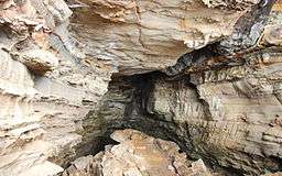
St Michaels Cave is situated in the Sydney suburb of Avalon Beach. This sea-side cave is around 110 metres long, 15 metres high and 10 metres wide. The original colonial owner was a Reverend John Therry, who planned to deliver lectures within the cave and build a church above it. The cave was formed by the erosion of a jurassic dyke through triassic sedimentary rocks. The cave is known to be a breeding site for Common bent-wing bats and Large-eared pied bats.[1][2][3][4][5][6]
See also
References
- ↑ "Calcite : Journal of the Highland Caving Group" (PDF). Hcg.org.au. Retrieved 2016-02-01.
- ↑ "Pittwater Council-Avalon Headland". nsw.gov.au.
- ↑ "01 Sep 1937 - ST. MICHAEL'S CAVE Avalon's Map of Australia". nla.gov.au.
- ↑ NSW Government Geological Series Sheet 9130 Edition 1, 1983
- ↑ Gregory Retallack. "Triassic Paleosols in the Upper Narrabeen Group of New South Wales. Part II: Classification and Reconstruction" (PDF). Blogs.uoregon.edu. Retrieved 2016-02-01.
- ↑ Retallack, Greg (1977). "Paleosols in the upper Narrabeen Group of New South Wales as evidence of Early Triassic paleoenvironments without modern analogues" (PDF). blogs.uoregon.edu. Australian Journal of Earth Sciences. Retrieved 21 October 2015.
This article is issued from
Wikipedia.
The text is licensed under Creative Commons - Attribution - Sharealike.
Additional terms may apply for the media files.