St Ives Rural District
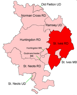
Coordinates: 52°22′N 0°04′W / 52.36°N 0.06°W St Ives was a rural district in Huntingdonshire from 1894 to 1974, surrounding the urban area of St Ives. It was formed under the Local Government Act 1894 from the part of the St Ives rural sanitary district which was in Huntingdonshire (the rest, being in Cambridgeshire, formed the Swavesey Rural District).
It was expanded slightly in 1935 by taking in part of the disbanded Hartford parish.
In 1965 Huntingdonshire and the Soke of Peterborough merged to form Huntingdon and Peterborough, and the area of St Ives RD was reducuced very slightly.
In 1974 the district was abolished under the Local Government Act 1972 and became part of the non-metropolitan district of Huntingdon, subsequently renamed Huntingdonshire.
Parishes[1]
| Parish | From | To | Notes |
|---|---|---|---|
| Bluntisham cum Earith | 1948 | Divided into Bluntisham and Earith | |
| Bluntisham | 1948 | ||
| Broughton | |||
| Bury | |||
| Colne | |||
| Earith | 1948 | Created by division of Bluntisham cum Earith | |
| Fenstanton | |||
| Hemingford Abbots | |||
| Hemingford Grey | |||
| Hilton | |||
| Holywell cum Needingworth | |||
| Houghton and Wyton | 1935 | Merger of Houghton, Wyton and part of Hartford from Huntingdon RD | |
| Houghton | |||
| Old Hurst | |||
| Pidley cum Fenton | |||
| Somersham | |||
| Warboys | |||
| Wistow | |||
| Woodhurst | |||
| Wyton | See Houghton and Wyton |
References
- ↑ "St Ives RD through time: Census tables with data for the Local Government District". A Vision of Britain through Time. GB Historical GIS / University of Portsmouth. Retrieved 11 June 2017.