Sankt Peter, Baden-Württemberg
| St. Peter | ||
|---|---|---|
| ||
 St. Peter Location of St. Peter within Breisgau-Hochschwarzwald district 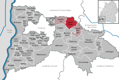  | ||
| Coordinates: 48°0′59″N 8°1′57″E / 48.01639°N 8.03250°ECoordinates: 48°0′59″N 8°1′57″E / 48.01639°N 8.03250°E | ||
| Country | Germany | |
| State | Baden-Württemberg | |
| Admin. region | Freiburg | |
| District | Breisgau-Hochschwarzwald | |
| Government | ||
| • Mayor | Gottfried Rohrer (CDU) | |
| Area | ||
| • Total | 35.93 km2 (13.87 sq mi) | |
| Elevation | 716 m (2,349 ft) | |
| Population (2017-12-31)[1] | ||
| • Total | 2,604 | |
| • Density | 72/km2 (190/sq mi) | |
| Time zone | CET/CEST (UTC+1/+2) | |
| Postal codes | 79271 | |
| Dialling codes | 07660 | |
| Vehicle registration | FR | |
| Website | www.st-peter-schwarzwald.de | |

Sankt Peter is a municipality in the district of Breisgau-Hochschwarzwald in Baden-Württemberg in Germany.
Geography
Location
St. Peter is a climatic spa located within the Southern Black Forest Nature Park, on the southern flank of the Kandel, about 12 miles east of Freiburg im Breisgau.
Administrative structure
To the municipality of St. Peter belong the village of Bürgerschaft, the hamlet of Sägendobel, the settlements of Kandelberg, Neuwelt, Oberibental, Ränke, Rohr, Schmittenbach, Schönhöfe, Seelgut and Willmendobel and the farmsteads of Eckpeterhof, Langeck and Lindlehof.
History
The Abbey of St. Peter in the Black Forest was founded in 1093 by the Duke of Zähringen, Berthold II as his house abbey and family burial site. The municipality developed gradually over time around the abbey.
When the estates of the Church were seized and sold or transferred during Napoleon's conquest of Europe, the village of St. Peter was handed to the Grand Duchy of Baden in 1806 and, since 1952, they have been part of the state of Baden-Württemberg.
In 1899, fire broke out in the village centre of St. Peter,[2] whereupon 23 houses were destroyed and 150 people made homeless.[3]
At the end of the Second World War there was a Reich training centre of the Hitler Youth in St. Peter.[4]
| Population growth | ||||||||||||||
|---|---|---|---|---|---|---|---|---|---|---|---|---|---|---|
| Year | 1806 | 1871 | 1900 | 1925 | 1939 | 1950 | 1961 | 1970 | 1989 | 1995 | 2005 | 2010 | 2015 | |
| Population | 1480 | 1308 | 1383 | 1378 | 1426 | 1500 | 1529 | 1797 | 2207 | 2362 | 2508 | 2547 | 2583 | |
Source: Statistisches Landesamt Baden-Württemberg (except 1806); 1871–1970: Census results
Gallery
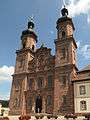 The abbey church of St. Peter and St. Paul
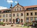 Gateway to the abbey courtyard (Klosterhof)
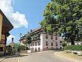 Steyrer Strasse
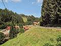 Panorama between Sankt Peter and the Glottertal valley
References
- ↑ "Bevölkerung nach Nationalität und Geschlecht am 31. Dezember 2017". Statistisches Landesamt Baden-Württemberg (in German). 2018.
- ↑ Karl Schmid; Hans Schadek: Die Zähringer. Anstoß und Wirkung. Thorbecke, Sigmaringen 1986, ISBN 3-7995-7041-1, p. 371
- ↑ Chronicle of the Municipality of St. Peter
- ↑ Arbeitsgemeinschaft Ebringer Dorfgeschichte (publ.): Ebringer Dorfgeschichte Nr. 2. Ebringen unterm Hakenkreuz. Zeitzeugenberichte, Ebringen 2008, pp. 33 and 38
External links
| Wikimedia Commons has media related to St. Peter (Hochschwarzwald). |
- (in German) St. Peter: History and images
- (in German) St. Peter