Gottenheim
| Gottenheim | ||
|---|---|---|
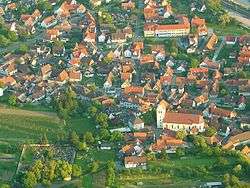 Aerial view | ||
| ||
 Gottenheim Location of Gottenheim within Breisgau-Hochschwarzwald district 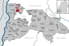  | ||
| Coordinates: 48°02′59″N 07°43′44″E / 48.04972°N 7.72889°ECoordinates: 48°02′59″N 07°43′44″E / 48.04972°N 7.72889°E | ||
| Country | Germany | |
| State | Baden-Württemberg | |
| Admin. region | Freiburg | |
| District | Breisgau-Hochschwarzwald | |
| Government | ||
| • Mayor | Christian Riesterer | |
| Area | ||
| • Total | 8.74 km2 (3.37 sq mi) | |
| Elevation | 207 m (679 ft) | |
| Population (2017-12-31)[1] | ||
| • Total | 2,966 | |
| • Density | 340/km2 (880/sq mi) | |
| Time zone | CET/CEST (UTC+1/+2) | |
| Postal codes | 79288 | |
| Dialling codes | 07665 | |
| Vehicle registration | FR | |
| Website | www.gottenheim.de | |

_jm20073.jpg)
_jm20107.jpg)
Gottenheim is an independent village at the northern tip of the Tuniberg, 15 km west of Freiburg im Breisgau. It is located in the administrative region Breisgau-Hochschwarzwald in the federal state of Baden-Württemberg, Germany.
Situated at an altitude of 207 m in one of the warmest regions of Germany, Gottenheim has a population of 2,500.
The total area of Gottenheim is 2183 acres (8.83 km²), which includes 275 acres (1.11 km2) of vines, 538 acres (2.18 km2) alluvial forest and some acres of half-bog.
History
Gottenheim was first officially mentioned in 1086.
Politics
Council
The last council election (Kommunalwahl) on the 13. of June 2004 lead to the following distribution of seats:
| FWG | 26,7% | 3 seats |
| SPD | 20,3% | 3 seats |
| CDU | 19,4% | 2 seats |
| Freie Bürger | 17,3% | 2 seats |
| Frauenliste | 16,3% | 2 seats |
Economy and Infrastructure
Transportation
The Breisgau S-Bahn operated Breisachbahn railway line connects Gottenheim to Breisach in the west and the national railway system (Deutsche Bahn) via Freiburg im Breisgau in the east. The Kaiserstuhlbahn connects Gottenheim to Endingen and the towns, Riegel am Kaiserstuhl, Nimburg and Bötzingen, which lay in between.
By car Gottenheim can be reached via German Autobahn A5, Frankfurt-Basel, using exit No.62 Freiburg-Mitte towards Umkirch and following signs.
Culture and sights
Festivals
- Gottenheim Hahlerai-fest (local wine and food festival) every second year in autumn
References
- ↑ "Bevölkerung nach Nationalität und Geschlecht am 31. Dezember 2017". Statistisches Landesamt Baden-Württemberg (in German). 2018.
External links
- Official homepage of Gottenheim
- (in German) Gottenheim - pictures & history
- Wine festival Gottenheim (all even years in beginning of September)
- Aerial views of Gottenheim
- Sports club Gottenheim