St. Louis Bay Bridge
| St. Louis Bay Bridge | |
|---|---|
 | |
| Coordinates | 30°19′04″N 89°18′15″W / 30.317692°N 89.304256°WCoordinates: 30°19′04″N 89°18′15″W / 30.317692°N 89.304256°W |
| Carries |
4 lanes of |
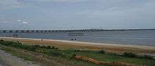
| Crosses | St. Louis Bay |
| Locale | Bay St. Louis and Pass Christian, Mississippi |
| Maintained by | MDOT |
| Characteristics | |
| Total length | 11,090 ft (3,380.2 m),[1] about 2.1 mi (3.4 km) |
| History | |
| Opened | May 17, 2007 |
The St. Louis Bay Bridge is a bridge in the U.S. state of Mississippi which carries U.S. Route 90 over Bay of Saint Louis between Bay St. Louis and Pass Christian. The original bridge was heavily damaged by Hurricane Katrina in August 2005. The bridge's deck and railroad tracks were ruined, but the piers withstood the storm surge and winds and provided a base for a new concrete deck.[2] The new bridge opened to traffic on May 17, 2007. The span carries 4 lanes of traffic as well as a 12-foot (3.7 m) path for pedestrians and bicyclists on the Gulf side of the bridge.
References
- ↑ https://bridgehunter.com/ms/hancock/bay-of-st-louis/
- ↑ Reginald DesRoches, PhD, ed. (2007). Hurricane Katrina: Performance of Transportation Systems. Reston, VA: ASCE, TCLEE. ISBN 9780784408797. Archived from the original on 2014-03-03.
This article is issued from
Wikipedia.
The text is licensed under Creative Commons - Attribution - Sharealike.
Additional terms may apply for the media files.