St. Clement, Missouri
| Saint Clement, Missouri | |
|---|---|
| Census-designated place | |
 Location of Saint Clement in Missouri | |
| Coordinates: 39°17′00″N 91°12′34″W / 39.28333°N 91.20944°WCoordinates: 39°17′00″N 91°12′34″W / 39.28333°N 91.20944°W | |
| Country | United States |
| State | Missouri |
| County | Pike |
| Elevation[1] | 814 ft (248 m) |
| Time zone | UTC-6 (Central (CST)) |
| • Summer (DST) | UTC-5 (CDT) |
| ZIP code | 63334 |
| Area code(s) | 573 |
| FIPS code | 29-29163 |
| GNIS feature ID | 64154[1] |
| [2] | |
Saint Clement is a census-designated place in Pike County, Missouri, United States, located on Route 161 approximately three miles south of Bowling Green.
The first settlement at St. Clement was made in 1870 by a colony of German Catholics.[3] A post office called Saint Clement was established in 1870, and remained in operation until 1882.[4]
References
- 1 2 U.S. Geological Survey Geographic Names Information System: Saint Clement, Missouri. Retrieved on 2008-03-09.
- ↑ "Saint Clement Missouri Zip Codes & Area Code - FIPS29163". postalcodelookup.ca. Retrieved 2008-03-09.
- ↑ "Pike County Place Names, 1928–1945". The State Historical Society of Missouri. Archived from the original on June 24, 2016. Retrieved December 7, 2016.
- ↑ "Post Offices". Jim Forte Postal History. Retrieved 7 December 2016.
Municipalities and communities of Pike County, Missouri, United States | ||
|---|---|---|
| Cities | 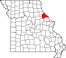 | |
| Villages | ||
| Townships | ||
| CDPs | ||
| Unincorporated communities | ||
| Ghost towns | ||
This article is issued from
Wikipedia.
The text is licensed under Creative Commons - Attribution - Sharealike.
Additional terms may apply for the media files.