Stępina
| Stępina | |
|---|---|
| Village | |
 "Hitler's Bunker" built in 1940-1941 | |
 Stępina | |
| Coordinates: 49°53′N 21°34′E / 49.883°N 21.567°E | |
| Country |
|
| Voivodeship | Subcarpathian |
| County | Strzyżów |
| Gmina | Frysztak |
| Population (approx.) | 920 |
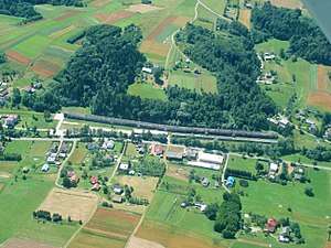
Stępina pronounced [stɛmˈpʲina] is a village in the administrative district of Gmina Frysztak, within Strzyżów County, Subcarpathian Voivodeship, in south-eastern Poland.[1] It lies approximately 7 kilometres (4 mi) north-west of Frysztak, 16 km (10 mi) west of Strzyżów, and 36 km (22 mi) south-west of the regional capital Rzeszów.
The village has an approximate population of 920.
World War II
 1 2 3 | |||||||
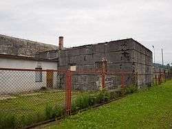
Hitler's Anlage Süd and his train bunker in Sępina
|
Stępina is the location of one of Hitler's bunkers called Anlage Süd, built in 1940-1941 with slave-labor from the Szebnie concentration camp nearby.[2] Over the course of the camp's operation some 10,000 people perished, including Soviet prisoners of war, Polish Jews, non-Jewish Poles, as well as Ukrainians and Romani people.[3]
The remains of the camp in Szebnie were entered by the Soviets on 8 September 1944 during counter-offensive of the Red Army.[3]
References
- ↑ "Central Statistical Office (GUS) – TERYT (National Register of Territorial Land Apportionment Journal)" (in Polish). 2008-06-01.
- ↑ Ronald Berger (12 July 2010). "Surviving the Concentration Camps" (Google Book). Surviving the Holocaust: A Life Course Perspective. Taylor & Francis. pp. 91–92. ISBN 0203848519. Retrieved 4 July 2013.
- 1 2 Jacek Bracik, Józef Twaróg (2003). "Obóz w Szebniach (Camp in Szebnie)" (in Polish). Region Jasielski, nr 3 (39). Archived from the original on February 1, 2010. Retrieved 4 July 2013.