Mukhalingam
| Mukhalingam Srimukhalingam | |
|---|---|
| Village | |
 Srimukhalingam temple | |
 Mukhalingam Location in Andhra Pradesh, India  Mukhalingam Mukhalingam (India) | |
| Coordinates: 18°36′00″N 83°58′00″E / 18.6000°N 83.9667°ECoordinates: 18°36′00″N 83°58′00″E / 18.6000°N 83.9667°E | |
| Country |
|
| State | Andhra Pradesh |
| District | Srikakulam |
| Talukas | Jalumuru |
| Population | |
| • Total | 3,204 |
| Languages | |
| • Official | Telugu |
| Time zone | UTC+5:30 (IST) |
| PIN | 532428 |
| Vehicle registration | AP 30 |
Mukhalingam is a village panchayat in Jalumuru mandal of Srikakulam district, Andhra Pradesh, India.
Geography
Mukhalingam is located at 18°35′39″N 83°57′49″E / 18.5943°N 83.9635°E.[1] It has an average elevation of 28 metres (92 ft).
Demographics
According to the 2011 Census of India, the demographic details of Mukhalingam are as follows:[2]
- Total Population: 3,022 in 837 Households
- Male Population: 1,504 and Female Population: 1,518
- Children under six years of age: 265 (Boys - 139 and Girls - 126)
- Literacy rate: 63.58%
Culture
The Srimukhalingeswara temple is a Shiva temple in the village, which was built by Kamarnava–II in 8th century AD of the Eastern Ganga dynasty.[3] Every year famous Chakratirtha snanam(holy bath) is taken by pilgrims . Lakhs of pilgrims visit from Odisha and Andhra Pradesh on the auspicious day to take the holy bath and take blessings of Lord Shiva.
Gallery
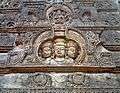 A relief of Trimurti on a dome at Sri Mukhalingam temple complex
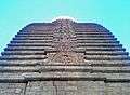 View of a dome at Sri Mukhalingam Temple complex
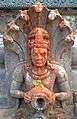 A relief carved out on walls for a drain at Sri Mukhalingam
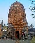 A Temple in Sri Mukhalingam temple complex
References
- ↑ "Maps, Weather, and Airports for Mukhalingam, India". www.fallingrain.com. Retrieved 2016-04-11.
- ↑ "Mukhalingam Village Population - Jalumuru - Srikakulam, Andhra Pradesh". www.census2011.co.in. Retrieved 2016-04-11.
- ↑ Linda, Mary F. (1990-01-01). "Nārāyaṇapuram: A Tenth Century Site in Kaliṅga". Artibus Asiae. 50 (3/4): 232–262. doi:10.2307/3250071. JSTOR 3250071.
| Wikimedia Commons has media related to Mukhalingam. |
This article is issued from
Wikipedia.
The text is licensed under Creative Commons - Attribution - Sharealike.
Additional terms may apply for the media files.