Spruce Hole Bog
| Spruce Hole Bog | |
|---|---|
 The Spruce Hole Bog | |
 Map of New Hampshire | |
| Location | Durham, New Hampshire |
| Coordinates | 43°07′34″N 70°58′04″W / 43.12611°N 70.96778°WCoordinates: 43°07′34″N 70°58′04″W / 43.12611°N 70.96778°W |
| Designated | 1972 |
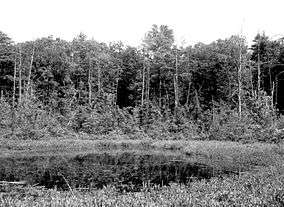
The Spruce Hole Bog, locally known as Spruce Hole, is a complete ecological community occupying a true kettle hole in the town of Durham, New Hampshire. According to the National Register of Natural Landmarks: "It illustrates characteristics of a typical sphagnum-heath bog, localized in a specialized geologic setting." It was designated a National Natural Landmark in 1972.[1] Spruce Hole is located two miles west of the town center of Durham, and is owned by the town which has conserved 35 acres around it. It is reached by a woods road off Packer's Falls Road, and despite the name the surrounding forest is mostly white pine, hemlock, and birch.
The bog is also adjacent to the Oyster River Forest, a permanently conserved 172± acre parcel owned by the Town of Durham.
References
- ↑ "Spruce Hole Bog". nps.gov. National Park Service.
External links
- Spruce Hole Bog and Conservation Area - Durham, New Hampshire
- Brief from the National Park Service.
- Spruce Hole locater map.