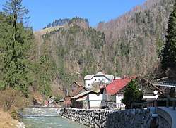
Spodnje Jezersko
| Spodnje Jezersko | |
|---|---|
 | |
 Spodnje Jezersko Location in Slovenia | |
| Coordinates: 46°22′54.81″N 14°28′7.28″E / 46.3818917°N 14.4686889°ECoordinates: 46°22′54.81″N 14°28′7.28″E / 46.3818917°N 14.4686889°E | |
| Country |
|
| Traditional region | Carinthia |
| Statistical region | Upper Carniola |
| Municipality | Jezersko |
| Area | |
| • Total | 27.84 km2 (10.75 sq mi) |
| Elevation | 715.2 m (2,346.5 ft) |
| Population (2002) | |
| • Total | 80 |
| [1] | |
Spodnje Jezersko (pronounced [ˈspoːdnjɛ jɛˈzɛːɾskɔ] (![]()
Geology
On the left bank of the Kokra River, about 2 km south of the settlement, thick layers of travertine are occasionally still mined, particularly for restoration of listed buildings in Upper Carniola, where it was traditionally used as a building material.[2]
Chapel

A masonry chapel dedicated to Saint Hubertus stands on a hill in the southern part of the settlement, in the hamlet of Zgornje Fužine. It is a single-nave structure with a belfry that was built in the Gothic Revival style in 1853. The chapel contains wooden furnishings and an oil painting of Saint Hubertus.[3]
References
- ↑ Statistical Office of the Republic of Slovenia
- ↑ Slovenian Tourist Board site
- ↑ "Spodnje Jezersko - Kapela sv. Huberta". Register kulturne dediščine. Retrieved April 12, 2018.
External links
- Spodnje Jezersko at Geopedia

| Settlements | Administrative centre: Zgornje Jezersko
|  |
|---|---|---|
| Landmarks |
| |