Sperryville, Virginia
| Sperryville | |
|---|---|
| Census-designated place (CDP) | |
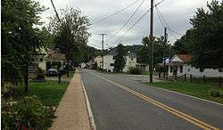 A view from Sperryville Pike | |
 Sperryville Location within the Commonwealth of Virginia | |
| Coordinates: 38°39′25″N 78°13′34″W / 38.65694°N 78.22611°WCoordinates: 38°39′25″N 78°13′34″W / 38.65694°N 78.22611°W | |
| Country | United States |
| State | Virginia |
| County | Rappahannock |
| Elevation | 700 ft (200 m) |
| Population (2010) | |
| • Total | 342 |
| Time zone | UTC−5 (Eastern (EST)) |
| • Summer (DST) | UTC−4 (EDT) |
| ZIP codes | 22740 |
| Area code(s) | 540 |
Sperryville is a census-designated place (CDP) in Rappahannock County, Virginia, United States. The population as of the 2010 Census was 342.[1]
History
Located in the southeast section of Rappahannock County, Virginia, along the Thornton River,[2] Sperryville was laid out by Francis Thornton, Jr. in 1817 and established in 1820 when the first deed was recorded.[3] For most of the early 19th century Conestoga wagons were built by John Kiger.[4] By the 1850, Sperryville boasted two turnpikes: Thornton's Gap and Sperryville & Rappahannock. In the 1860s the Smoot family of Alexandria build a tannery on the Thornton River[5] that closed by 1911. By that time Sperryville had grown to 350 residents with four churches, five general stores, one hotel, six mills, shops, and a masonic hall. The Sperryville Historic District is listed on the Virginia Landmarks Registry and the National Register of Historic Places.[6]
Attractions
Sperryville is close to many outdoor activities. The town is at the foothills of the Blue Ridge Mountains and provides access to the panorama entrance[7] of Shenandoah National Park that provides access to Skyline Drive,[8] which is a continuation of the Blue Ridge Parkway of the Great Smoky Mountains. Hiking spots include the popular Old Rag Mountain,[9] White Oak Canyon,[10] and Thornton River Trail,[11] which are all located within the Shenandoah National Park.
The Copper Fox Distillery, a distiller of American whiskey, is based in Sperryville. Central Coffee Roasters, a small batch artisan coffee roaster, is located 1/2 mile west towards the Shenandoah National Park. Haley Fine Art, located on main street, features paintings, sculptures and photography by local and regional artists.
Sperryville is the setting for parts of the 8th Jack Reacher novel, The Enemy, by Lee Child.
Further reading
- Hanson, Raus (1969). From Virginia Place Names. Verona, Virginia: McClure Press. ISBN
- Arnold, Scott (2007). A Guidebook to Virginia's Historical Markers. Charlottesville: University of Virginia Press. ISBN 978-0-8139-2572-1.
- Hite, Mary (1950). My Rappahannock (Virginia) Story Book. Richmond, Virginia: The Dietz Press Incorpotated. ISBN
- Lynch, Kathryn (2007). Images of America: Rappahannock County. Charleston, SC: Arcadia Publishing. ISBN 0-7385-4384-5.
- McCarthy, Eugene (1984). The View from Rappahannock. McLean, Virginia: EPM Publications, Inc.. ISBN 0-914440-79-9.
References
- ↑ Virginia Trend Report 2: State and Complete Places (Sub-state 2010 Census Data). Missouri Census Data Center. Accessed 2011-06-08.
- ↑ "Get to Know Rappahannock". County of Rappahannock. Retrieved April 5, 2011.
- ↑ Rappahannock Historical Society. "Between 1820 and 1841 there are multiple deeds recorded in Culpeper and Rappahannock counties in which Francis VI sold the land that he had inherited from John Augustine Thornton. The first of these deeds in 1820 was for the sale of Lot 6 containing one-half acre in "a little town laid off by me, the said Francis Thornton Jr. and surveyed by Johnston Menefee … the village is in a flat adjoining the lands of John Menefee between the Pass Mill (today's Fletcher's Mill) and Thorntons Gap."
- ↑ Arnold, Scott (2007). A Guidebook to Virginia's Historical Markers. Charlottesville: University of Virginia Press. p. 73.
- ↑ Hite, Mary (1950). My Rappahannock (Virginia) Story Book. Richmond, Virginia: The Dietz Press Incorporated. pp. 143–145.
- ↑ Lynch, Kathryn (2007). Images of America: Rappahannock County. Charleston, SC: Arcadia Publishing. pp. 45–70.
- ↑ "Welcome to Sperryville, VA". ShenValley Web Hosting. Retrieved April 6, 2011.
- ↑ Silas House (2006). Encyclopedia of Appalachia.
- ↑ Virginia Economic Development Partnership. "Sperryville, VA". Virginia is for Lovers. Retrieved April 6, 2011.
- ↑ National Park Service. "White Oak Canyon Trail and Route Map" (PDF). Department of the Interior. Retrieved April 12, 2010.
- ↑ "Thornton River Trail". Trails.com, Inc. Retrieved April 12, 2011.
External links
- waterpennyfarm.com
- centralcoffeeroasters.com
- mountvernonfarm.net
- haleyfineart.com
- hopkinsordinary.com
- nps.gov
Municipalities and communities of Rappahannock County, Virginia, United States | ||
|---|---|---|
| Town |  | |
| CDPs | ||
| Unincorporated communities |
| |
| Footnotes | ‡This populated place also has portions in an adjacent county or counties | |