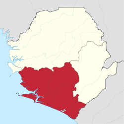
Southern Province, Sierra Leone
| Southern Province | |
|---|---|
 | |
| Country | Sierra Leone |
| Capital | Bo |
| Area | |
| • Total | 19,694 km2 (7,604 sq mi) |
| Population (2015 census) | |
| • Total | 1,438,572 |
| • Density | 73/km2 (190/sq mi) |
| Time zone | UTC+0 (Greenwich Mean Time) |
The Southern Province is one of the four provinces of Sierra Leone. It covers an area of 19,694 km² and has a population of 1,438,572 (2015 census). It consists of four districts (Bo, Bonthe, Moyamba, and Pujehun). Its capital and administrative center is Bo, which is also the second largest and second most populated city in Sierra Leone after the nation's capital Freetown. The population of the southern province is largely from the Mende ethnic group.
Geography
Districts
The province is divided into 4 districts.
- Bo District, capital Bo
- Bonthe District, capital Mattru Jong
- Moyamba District, capital Moyamba
- Pujehun District, capital Pujehun
Borders
Southern Province has the following borders:
- Western Area: far northwest
- Northern Province: north
- Eastern Province: east
- Grand Cape Mount County, Liberia: southeast
To the south and west of Southern Province is the Atlantic Ocean.
Ecology
Sierra Leone's last remaining stand of rainforest is at Gola.[1]
See also
References
External links
| Wikimedia Commons has media related to Provinces of Sierra Leone. |
- 3230990 Southern Province on OpenStreetMap
This article is issued from
Wikipedia.
The text is licensed under Creative Commons - Attribution - Sharealike.
Additional terms may apply for the media files.