South Swale
| South Swale | |
|---|---|
 | |
| Type | Local Nature Reserve |
| Location | Faversham, Kent |
| OS grid | TR 047 653 |
| Area | 410.5 hectares (1,014 acres) |
| Managed by | Kent Wildlife Trust |
South Swale is a 410.5-hectare (1,014-acre) Local Nature Reserve (as South Bank of the Swale) north of Faversham in Kent. It is owned by Kent County Council and managed by Kent Wildlife Trust.[1][2][3] It is part of The Swale Ramsar site,[4] Special Protection Area[5] and Site of Special Scientific Interest[6]
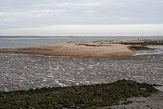
This coastal site has wetland and grassland, with mudflats which attract a large population of waders and wildfowl in winter. Flora include Yellow horned-popies, sea-lavender, golden samphires and wild carrots.[3]
The Saxon Shore Way public footpath follows the top of the sea wall for the entire length of the reserve, around the village of Graveney, for about 3 miles in total. [7]
See also
- Oare Marshes - across Faversham Creek from South Swale
| Wikimedia Commons has media related to South Swale. |
References
- ↑ "South Bank of the Swale". Local Nature Reserves. Natural England. Retrieved 7 March 2018.
- ↑ "Map of South Bank of the Swale". Local Nature Reserves. Natural England. Retrieved 7 March 2018.
- 1 2 "South Swale". Kent Wildlife Trust. Retrieved 26 January 2018.
- ↑ "Designated Sites View: The Swale". Ramsar Site. Natural England. Retrieved 22 January 2018.
- ↑ "Designated Sites View: The Swale". Special Protection Area. Natural England. Retrieved 22 January 2018.
- ↑ "Designated Sites View: The Swale". Sites of Special Scientific Interest. Natural England. Retrieved 22 January 2018.
- ↑ http://www.faversham.org/pages/standard.aspx?i_PageID=1176 Archived September 10, 2011, at the Wayback Machine.
This article is issued from
Wikipedia.
The text is licensed under Creative Commons - Attribution - Sharealike.
Additional terms may apply for the media files.