South Peninsula, Sulawesi
| Semenanjung Selatan | |
|---|---|
 The South Peninsula is the peninsula in the southern part of Sulawesi | |
| Geography | |
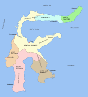
| Location | Sulawesi |
| Highest elevation | 3,478 m (11,411 ft) |
| Highest point | Mount Latimojong |
| Administration | |
| Province | South Sulawesi |
| Capital and largest city | Makassar |
| Demographics | |
| Population | 8 million |
The South Peninsula is one of the four principal peninsulas on the island of Sulawesi, stretching south from the central part of the island. It is part of the province of South Sulawesi. The southern peninsula is the most densely populated peninsula in Sulawesi, even nearly half the population of Sulawesi or 8 million people are on the southern peninsula. Inhabited by an austronesian people who came thousands of years ago. The largest ethnic group in Sulawesi is the Bugis, followed by Makassar and Toraja.
South Peninsula and Sulawesi was first inhabited by humans about 30,000 years ago. The archaeological remains of the earliest inhabitants were discovered in caves near limestone hills around Maros, about 30 km northeast of Makassar, the capital of the South Sulawesi province. Peeble and flake stone tools have been collected from the river terraces in the valley of Walanae, among Soppeng and Sengkang, including the bones from giant pig and elephant species that are now extinct. Hand print paintings, estimated to be around 35,000 to 40,000 years old, have been found in the Pettakere cave,[8] located 12 kilometres (7.5 mi) from the town of Maros and 30 kilometres (19 mi) from Makassar.
Mount Lompobattang lies near the southern tip of this peninsula. and the latimojong mountain is the highest mountain in the southern peninsula of sulawesi and on the island of sulawesi.