South Kilvington
| South Kilvington | |
|---|---|
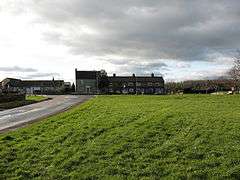 Village Green, South Kilvington | |
 South Kilvington South Kilvington shown within North Yorkshire | |
| Population | 243 (2011 census)[1] |
| OS grid reference | SE425840 |
| Civil parish |
|
| District | |
| Shire county | |
| Region | |
| Country | England |
| Sovereign state | United Kingdom |
| Post town | THIRSK |
| Postcode district | YO7 2 |
| Police | North Yorkshire |
| Fire | North Yorkshire |
| Ambulance | Yorkshire |
| EU Parliament | Yorkshire and the Humber |
| UK Parliament | |
South Kilvington is a village and civil parish in the Hambleton district of North Yorkshire, England. It is situated just off the A19, about one mile north of Thirsk.
History
The village is mentioned in the Domesday Book as Cheluitun in the Yarlestre hundred. The entry refers to the area around North Kilvington that was owned by Earl Edwin at the time of the Norman invasion and then granted to the Crown.[2] During the 13th century, the lands became the demesne of Roger of Mowbray and around 1637, after many lands had been divided, the lord of the manor was Sir Arthur Ingram.[3]
Henry Percy, 4th Earl of Northumberland was supposedly killed here in 1489 by a mob of protesters against taxation.[4]
Governance
The village lies within the Thirsk and Malton UK Parliament constituency. It also lies within the Thirsk electoral division of North Yorkshire County Council and the Whitestonecliffe ward of Hambleton District Council.[5]
Geography
The original route of the A19 used to run through the village, it is now the A61. Cod Beck flows to the west of the village as part of the tributary system of the River Swale.[5]
The 1881 UK Census recorded the population as 261.[3] In the 2001 census, the parish had a population of 231 of which 205 were over sixteen years old and 102 of those were in employment. There were 112 dwellings of which 72 were detached.[6]
Education
The village has a school, South Kilvington CE Primary. The school is in the catchment area for Thirsk School & Sixth Form College.[7]
Religion
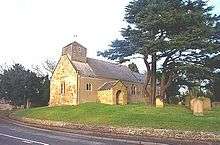
There is a church in the village dedicated to St Wilfrid. It is thought to date from the reign of Henry III. Some Saxon cross remains in the churchyard indicate that there may have been an older structure here. The church is a Grade II* listed building.[3][8]
References
- ↑ UK Census (2011). "Local Area Report – South Kilvington Parish (1170216925)". Nomis. Office for National Statistics. Retrieved 11 June 2018.
- ↑ Kilvington in the Domesday Book. Retrieved 30 December 2012.
- 1 2 3 Bulmer's Topography, History and Directory (Private and Commercial) of North Yorkshire 1890. S&N Publishing. 1890. p. 728. ISBN 1-86150-299-0.
- ↑ Oxford Dictionary of National Biography, accessed 4 December 2010
- 1 2 Ordnance Survey Open Viewer
- ↑ "2001 UK Census". Neighbourhood Statistics. Office for National Statistics. Retrieved 30 December 2012.
- ↑ "Browse school information for your area". North Yorkshire County Council. Retrieved 13 December 2017.
- ↑ "Church Listing". Retrieved 30 December 2012.
External links
![]()