South Grand Island Bridge
| South Grand Island Bridge | |
|---|---|
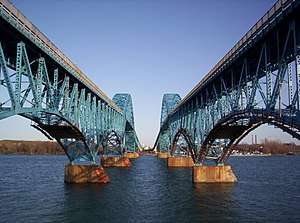 South Grand Island Bridge from Grand Island (from northwest; Niagara River flows left, northeast) | |
| Coordinates | 42°59′54″N 78°56′14″W / 42.99833°N 78.93722°W |
| Carries |
Four lanes of |
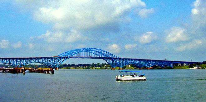
| Crosses | Niagara River |
| Locale | Tonawanda, New York and Grand Island, New York |
| Maintained by | New York State Thruway Authority |
| Characteristics | |
| Design | Twin truss through arch bridges |
| Total length | 3,400 feet (1,036 m) |
| Longest span | 182 m |
| History | |
| Opened |
|
| Statistics | |
| Toll | $1.00 (northbound) (E-ZPass) |
The South Grand Island Bridge is a pair of twin two-lane truss arch bridges spanning the Niagara River between Tonawanda and Grand Island in New York, United States. Each bridge carries one direction of Interstate 190 (I-190) and New York State Route 324 (NY 324). Both crossings are operated by the New York State Thruway Authority as part of the Niagara Thruway. The southbound span was opened in 1935 and acquired by the State of New York in 1950. The northbound span was finished in 1963. A northbound-only toll is collected on the Tonawanda side of the bridge.
Description
The bridges are twin truss arch bridges with a steel through-arch in the middle. Both crossings have a 93-foot (28 m) navigation clearance,[1] which was designed to allow tall lake freighters and tanker ships to pass beneath it. A toll is collected from all northbound traffic through a cashless toll system that allows vehicles to travel at highway speed without slowing down. Vehicles are billed by mail or through existing EZ-pass accounts.
Open-road cashless tolling began on the Grand Island South Crossing which carries northbound traffic on March 29, 2018. Drivers are no longer able to pay cash at the bridge. Instead, there are cameras mounted onto new overhead gantries will have two lanes instead of six which is just after the bridge and before the Grand Island Boulevard exit. For E-ZPass users, sensors will detect their transponders wirelessly. Drivers without E-ZPass will have a picture of their license plate taken, and the toll will be mailed to them.
Once the cashless tolling system starts, drivers will go through one of three remaining toll booth lanes in both directions without stopping. The speed limit through the old toll booth plaza is 20 mph. The old toll booths will be removed in phases in the future, so drivers should be aware of changing traffic patterns. There are three phases as part of the cashless tolls. The 1st Phase will be removing three toll booths on the left side. 2nd Phase will be removing three remaining toll booths on the right side and then the 3rd Phase will be reduced to two lanes with a new on-ramp lane to merge left.
History
The southbound bridge was completed in 1935. Mr. Frank J. Offermann, Sr., the former Sheriff of Erie County, owner of the Buffalo Bisons Ball Club and prominent resident of Grand Island was active in getting the bridges sanctioned. Also in 1935 after his untimely death, Supervisor Messmer proposed changing the name of the boulevard connecting the Grand Island Bridges to Offermann Drive, however this was never done, reference Buffalo Courier Express Feb 14, 1935.[2] as a two-lane, two-way structure carrying NY 325 from Tonawanda to Grand Island.[3] It became part of NY 324 by 1937.[4] In 1950, the State of New York assumed ownership of the bridge as part of the Niagara Thruway's construction. A twin bridge erected to the northeast of the original structure was completed in 1963,[5] at which time all northbound traffic was moved onto the new crossing and the 1935 span became southbound-only.
The 1935 span that now carries southbound traffic is behind the 1963 northbound span.
While the twin bridges were built decades apart, they appear nearly identical. It is clear that builders in the 1960s took great care in matching the original 1930s architecture, but there are slight differences. The 1935 bridge has stone cutwaters on the piers, while the 1963 bridge has steel-faced cutwaters.[1] Also, renovations of the southbound bridge have created a guard rail that looks quite different from the one on the northbound bridge.
The northbound span was renovated by American Bridge Company from 2008 to 2010.[6] American Bridge Company replaced the deck (road), sidewalk, and barriers as part of a $48 million project.[7]
See also

- List of crossings of the Niagara River
- North Grand Island Bridge
References
- 1 2 "South Grand Island Bridges". HistoricBridges.org. May 28, 2007. Retrieved November 11, 2012.
- ↑ Federal Highway Administration (2012). "NBI Structure Number: 5043981". National Bridge Inventory. Federal Highway Administration.
- ↑ Niagara Falls and Vicinity (Map). Cartography by H.M. Gousha Company. Shell Oil Company. 1935. Archived from the original on March 27, 2009. Retrieved December 31, 2009.
- ↑ New York (Map). Cartography by General Drafting. Standard Oil Company. 1937.
- ↑ Federal Highway Administration (2012). "NBI Structure Number: 5043982". National Bridge Inventory. Federal Highway Administration.
- ↑ Kates, Tasha (August 7, 2007). "Grand Island Bridges: Structures are in need of repair". Tonawanda News. Archived from the original on July 11, 2009. Retrieved November 11, 2012.
- ↑ "Thruway Authority Announces South Grand Island Bridge, Northbound, Deck Work to Commence Overnight Beginning Monday, April 5, 2010" (Press release). New York State Thruway Authority. March 30, 2010. Archived from the original on July 24, 2011. Retrieved November 11, 2012.
External links
- Pictures of South Grand Island Bridges 8-4-07
- Highlights of the History of Grand Island, NY
- American Bridge Company
Bridges of the Niagara River | ||||
|---|---|---|---|---|
| ||||