South Fork Elk River
| South Fork Elk River[1] | |
|---|---|
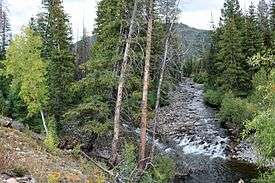 The mouth of the South Fork Elk River (right), where it empties into the Elk River. | |
| Physical characteristics | |
| Main source | 40°41′15″N 106°42′46″W / 40.68750°N 106.71278°W |
| River mouth |
Confluence with Elk River 7,680 ft (2,340 m) 40°45′20″N 106°48′50″W / 40.75556°N 106.81389°WCoordinates: 40°45′20″N 106°48′50″W / 40.75556°N 106.81389°W |
| Basin features | |
| Progression | Elk—Yampa—Green—Colorado |
The South Fork Elk River is a 13.5-mile-long (21.7 km)[2] stream in Colorado in the United States. It flows from a source near Dome Lake in Routt National Forest north of Steamboat Springs to a confluence with the Elk River.
See also
References
- ↑ "South Fork Elk River". Geographic Names Information System. United States Geological Survey. Retrieved 2011-01-27.
- ↑ U.S. Geological Survey. National Hydrography Dataset high-resolution flowline data. The National Map, accessed March 18, 2011
This article is issued from
Wikipedia.
The text is licensed under Creative Commons - Attribution - Sharealike.
Additional terms may apply for the media files.