South Dakota Highway 32
| ||||
|---|---|---|---|---|
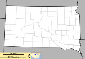 Map of South Dakota with SD 32 in red | ||||
| Route information | ||||
| Defined by SDCL §31-4-155 | ||||
| Maintained by SDDOT | ||||
| Length | 8.643 mi[1] (13.910 km) | |||
| Existed | c. 1970 – present | |||
| Major junctions | ||||
| West end |
| |||
| East end |
| |||
| Location | ||||
| Counties | Moody | |||
| Highway system | ||||
| ||||

South Dakota Highway 32 (SD 32) is a 8.643-mile-long (13.910 km) state highway in the east-central part of the U.S. state of South Dakota. It connects the west-central part of Moody County with Flandreau.
Route description
SD 32 begins at an interchange with Interstate 29 (I-29) approximately 5 miles (8.0 km) north-northeast of Colman, in the west-central part of Moody County. This intersection is just northeast of the Sioux Prairie Preserve. At this intersection, the roadway continues to the west as 230th Street. SD 30 takes 230th Street to the east. Just west of 475th Avenue, it crosses over Squaw Creek. East of 478th Avenue, it curves to the east-southeast. Just east of 479th Avenue, it crosses over the Big Sioux River and then enters the northwestern part of Flandreau. An intersection with Industrial Road leads to the Flandreau city office. The highway then curves back to the east. It intersects 12th Street, which leads to the Flandreau public schools, county resource center, aquatic center, and community center. Between Wind and Crescent streets, the highway passes the Moody County Courthouse. An intersection with Prairie Street leads to the Flandreau Medical Center. Just east of Lindsay Street, it intersects SD 13 (Summit Street). Here, SD 32 ends, and Pipestone Avenue continues to the east, leading to the Moody County Museum, Flandreau City Park, and the Flandreau Park Golf Course.
No part of SD 32 is included as part of the National Highway System,[2] a system of routes determined to be the important for the nation's economy, mobility and defense.
History
SD 32 was established around 1970. It has remained unchanged since.
Major intersections
The entire route is in Moody County.
| Location | mi[1] | km | Destinations | Notes | |
|---|---|---|---|---|---|
| | 0.000– 0.162 | 0.000– 0.261 | Western terminus of SD 32; roadway continues to the west as 230th Street; I-29 exit 114. | ||
| Flandreau | 8.643 | 13.910 | Eastern terminus; roadway continues to the east as Pipestone Avenue. | ||
| 1.000 mi = 1.609 km; 1.000 km = 0.621 mi | |||||
See also

References
- 1 2 "State Highway Log – Mitchell Region" (PDF). South Dakota Department of Transportation. January 2017. p. 49–50. Retrieved February 13, 2018.
- ↑ National Highway System: South Dakota (PDF) (Map). Federal Highway Administration. March 25, 2015. Retrieved February 13, 2018.
External links
Route map: