South Dakota Highway 240
| ||||
|---|---|---|---|---|
| Badlands Loop | ||||
 | ||||
| Route information | ||||
| Defined by SDCL §31-4-216 | ||||
| Maintained by SDDOT | ||||
| Length | 40.033 mi[1] (64.427 km) | |||
| Major junctions | ||||
| West end |
| |||
|
| ||||
| East end |
| |||
| Location | ||||
| Counties | Pennington, Jackson | |||
| Highway system | ||||
| ||||

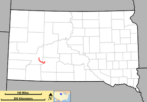
South Dakota Highway 240 (SD 240), also signed as the Badlands Loop, is a 40.033-mile-long (64.427 km) state highway located in the southeastern part of Pennington and the northwestern part of Jackson counties of the southwestern part of the U.S. state of South Dakota. It travels through the eastern portion of Badlands National Park.
Route description
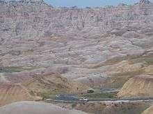
SD 240 begins in Wall at exit 110 of Interstate 90 (I-90). From this point, it travels south to Badlands National Park, where it turns southeast. At the Badlands Headquarters at Cedar Pass, the highway turns northeast, ending at exit 131 of I-90 near Cactus Flat. The total length of SD 240 is approximately 40 miles (64 km). Because the route enters a national park, there is an entrance fee charged along the highway at either entrance to the park. The fee is $15 per passenger vehicle, good for 7 days.
History
Eastern portions of the highway that are currently SD 240 (generally from the park headquarters to Cactus Flat) were originally part of the original alignment of SD 40. Construction began in the early 1930s. By 1944, a gravel surface was on the Badlands Loop alignment, and by the late 1940s, the Badlands Loop was signed as U.S. Route 16 Alternate (US 16 Alt.), in addition to SD 40 along the eastern portion of the loop. These two numbers were used until the early 1970s, when the SD 40 number was replaced by an extension of SD 44 (which entered the park from the southeast rather than the northeast).
Around 1980, US 16, which traveled concurrently with I-90, was truncated at its eastern end to Rapid City. Since US 16 Alt. no longer met the parent route, the route number was changed to SD 240.
Major intersections
| County | Location | mi[1] | km | Destinations | Notes |
|---|---|---|---|---|---|
| Pennington | Wall | 0.000 | 0.000 | Western terminus of SD 240; eastern terminus of I-90 Bus.; southern terminus of Glenn Street; I-90 exit 110 | |
| Jackson | Badlands National Park | 31.512 | 50.714 | Northern terminus of SD 377 | |
| | 40.033 | 64.427 | Eastern terminus; roadway continues as Cottonwood Road; I-90 exit 131 | ||
| 1.000 mi = 1.609 km; 1.000 km = 0.621 mi | |||||
References
- 1 2 "Transportation Inventory Management". South Dakota Department of Transportation. Retrieved December 17, 2011.
External links
Route map: