South Dakota Highway 123
| ||||
|---|---|---|---|---|
 | ||||
| Route information | ||||
| Defined by SDCL §31-4-192 | ||||
| Maintained by SDDOT | ||||
| Length | 10.486 mi[1] (16.876 km) | |||
| Major junctions | ||||
| South end |
| |||
| North end |
| |||
| Location | ||||
| Counties | Grant, Roberts | |||
| Highway system | ||||
| ||||

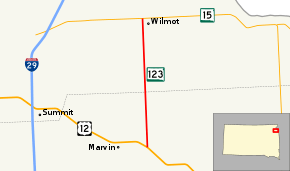
South Dakota Highway 123 (SD 123) is a 10.486-mile-long (16.876 km) state highway in the U.S. state of South Dakota that runs from U.S. Route 12 (US 12) near Marvin to SD 15 in Wilmot. It is maintained by the South Dakota Department of Transportation (SDDOT), and is not part of the National Highway System.
Route description
SD 123 begins at an intersection with US 12 east of Marvin in Grant County and begins north through open plains. The highway enters Roberts County 4.615 miles (7.427 km) north of its southern terminus and continues north through rolling farmland. North of the county line, the route enters the city of Wilmot. Here, SD 123 meets its northern terminus at an intersection with SD 15.[2][3]
SD 123 is maintained by SDDOT. In 2011, SDDOT measured the amount of traffic on its highways in average annual daily traffic. SD 123 had an average of 217 vehicles, including 31 trucks.[4] The highway is not a part of the National Highway System,[5] a system of highways important to the nation's defense, economy, and mobility.[6]
Major intersections
| County | Location | mi[1] | km | Destinations | Notes |
|---|---|---|---|---|---|
| Grant | Osceola–Kilborn township line | 0.000 | 0.000 | Southern terminus | |
| Roberts | Wilmot | 10.486 | 16.876 | Northern terminus | |
| 1.000 mi = 1.609 km; 1.000 km = 0.621 mi | |||||
References
- 1 2 "State Highway Log" (PDF). South Dakota Department of Transportation. January 2012. Retrieved March 3, 2013.
- ↑ Google (March 3, 2013). "South Dakota Highway 123" (Map). Google Maps. Google. Retrieved March 3, 2013.
- ↑ South Dakota Atlas & Gazetteer. Yarmouth, ME: DeLorme. 2009. pp. 22, 34. ISBN 0-89933-330-3.
- ↑ 2011 South Dakota Traffic Flow Map (PDF) (Map). South Dakota Department of Transportation. Retrieved March 3, 2013.
- ↑ National Highway System: South Dakota (PDF) (Map). Federal Highway Administration. October 1, 2012. Retrieved March 3, 2013.
- ↑ Natzke, Stefan; Neathery, Mike; Adderly, Kevin (September 26, 2012). "What is the National Highway System?". National Highway System. Federal Highway Administration. Retrieved March 3, 2013.
External links
Route map: