South Cascade Glacier
| South Cascade Glacier | |
|---|---|
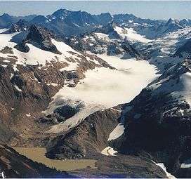 South Cascade Glacier, October 2000. Note how far the glacier has retreated since the 1965 photo below. | |
 South Cascade Glacier Location in Washington | |
| Type | Alpine glacier |
| Location | North Cascades, Skagit County, Washington, USA |
| Coordinates | 48°21′36″N 121°03′27″W / 48.36000°N 121.05750°WCoordinates: 48°21′36″N 121°03′27″W / 48.36000°N 121.05750°W[1] |
| Length | 1.3 mi (2.1 km) |
| Terminus | Talus/moraine |
| Status | Retreating |
South Cascade Glacier is a large alpine glacier in the North Cascades of Washington, USA.[2] It is bordered on the east by 8,261-foot (2,518 m) Sentinel Peak, and is about 17 mi (27 km) north of Glacier Peak in the Glacier Peak Wilderness. Meltwater from the glacier flows directly into South Cascade Lake, which feeds the South Fork Cascade River, which is a tributary of the Skagit River.
The South Cascade Glacier has been closely monitored by glaciologists studying the effects of climate on glaciers. Between 1958 and 2009 South Cascade Glacier lost nearly a half of its volume.[3]

South Cascade Glacier on September 23, 1965
See also
References
- ↑ "South Cascade Glacier". Geographic Names Information System. United States Geological Survey. Retrieved 2012-10-20.
- ↑ Dome Peak, WA (Map). TopoQwest (United States Geological Survey Maps). Retrieved 2012-10-20.
- ↑ Josberger, Bidlake, March, O'Neel (2009), Fifty-Year Record of Glacier Change Reveals Shifting Climate in the Pacific Northwest and Alaska, USA: U.S. Geological Survey Fact Sheet 2009-3046
This article is issued from
Wikipedia.
The text is licensed under Creative Commons - Attribution - Sharealike.
Additional terms may apply for the media files.