South Arkansas River
| South Arkansas River[1] | |
|---|---|
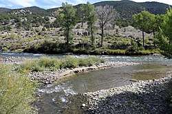 The confluence of the South Arkansas River (bottom) with the Arkansas River. | |
| Physical characteristics | |
| Main source | 38°29′53″N 106°19′53″W / 38.49806°N 106.33139°W |
| River mouth |
Confluence with Arkansas 7,001 ft (2,134 m) 38°31′16″N 105°58′40″W / 38.52111°N 105.97778°WCoordinates: 38°31′16″N 105°58′40″W / 38.52111°N 105.97778°W |
| Basin features | |
| Progression | Arkansas—Mississippi |
South Arkansas River is a 24.5-mile-long (39.4 km)[2] tributary of the Arkansas River that flows from a source near Monarch Pass in the Sawatch Range of southern Colorado. It joins the Arkansas just south of Salida, Colorado.
See also
References
- ↑ "South Arkansas River". Geographic Names Information System. United States Geological Survey. Retrieved 2011-01-30.
- ↑ U.S. Geological Survey. National Hydrography Dataset high-resolution flowline data. The National Map, accessed March 31, 2011
This article is issued from
Wikipedia.
The text is licensed under Creative Commons - Attribution - Sharealike.
Additional terms may apply for the media files.