Sornfelli
The mountain Sornfelli has a height of 749 m
Sornfelli is a mountain plateau on the island of Streymoy in the Faroe Islands about 12 km from the capital Tórshavn (20 km by road). It is the site of a military station at 725 m asl. The Sornfelli Meteorological Station installed in 1999 is located in the middle of the 40000 m2 Sornfelli Mountain top plateau at 725 m asl.
Temperatures at the meteorological station in 2000 were:
- Mean annual air temperature: +1.7 °C
- Mean coldest month (April): -2.2 °C
- Mean warmest month (August): 6.5 °C
From Tórshavn you can drive over the mountain road "Oyggjarvegin" to the Sornfelli Mountain plateau. There is a public road up to the Sornfelli Mountain plateau, but not the last 200 m to the radar base. The mountain Sornfelli has a height of 749 m.
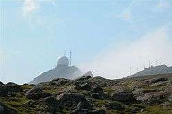 Radar base
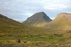
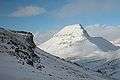 Sornfelli 749 m
.JPG) Sornfelli plateau
Sornfelli plateau.JPG) Sornfelli plateau
Sornfelli plateau
References
| Wikimedia Commons has media related to Sornfelli. |
- Scannet (2007). "Sornfelli". Scandinavian / North European Network of Terrestrial Field Bases. Retrieved 2007-06-09.
Coordinates: 62°05′0″N 6°50′0″W / 62.08333°N 6.83333°W
This article is issued from
Wikipedia.
The text is licensed under Creative Commons - Attribution - Sharealike.
Additional terms may apply for the media files.