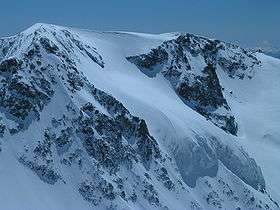
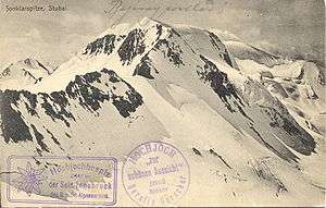
Sonklarspitze
| Sonklarspitze | |
|---|---|
 | |
| Highest point | |
| Elevation | 3,467 m (11,375 ft) |
| Prominence | 169 [1] |
| Isolation | 1.3 kilometres (0.81 mi) |
| Parent peak | Zuckerhütl |
| Coordinates | 46°57′20″N 11°09′53″E / 46.95556°N 11.16472°ECoordinates: 46°57′20″N 11°09′53″E / 46.95556°N 11.16472°E |
| Geography | |
| Location | Tyrol, Austria / South Tyrol, Italy |
| Parent range | Stubai Alps |
| Climbing | |
| First ascent | 5 August 1869 by Richard Gutberlet, Alois Tanzer and S. Holzmann |
The Sonklarspitze, also Sonklarspitz, is a mountain in the Stubai Alps on the border between Tyrol, Austria, and South Tyrol, Italy.
References
- DAV Sektion Siegerland: "Söldens Stille Seite", 1st ed. 2008, Hiking guide about the Windachtal and the surrounding huts, Verlag Vorländer Siegen, ISBN 978-3-923483-90-7
- Walter Klier: Alpenvereinsführer Stubaier Alpen, Munich 2006, ISBN 3-7633-1271-4
- Alpine Club Map 1:25.000, Sheet 31/1, Stubaier Alpen, Hochstubai
External links
![]()
This article is issued from
Wikipedia.
The text is licensed under Creative Commons - Attribution - Sharealike.
Additional terms may apply for the media files.