Soknedal
| Soknedal | |
|---|---|
| Village | |
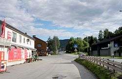 View of the village | |
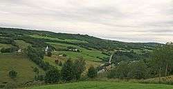
 Soknedal Location of the village  Soknedal Soknedal (Norway) | |
| Coordinates: 62°57′04″N 10°11′17″E / 62.9510°N 10.1881°ECoordinates: 62°57′04″N 10°11′17″E / 62.9510°N 10.1881°E | |
| Country | Norway |
| Region | Central Norway |
| County | Trøndelag |
| District | Gauldalen |
| Municipality | Midtre Gauldal |
| Area[1] | |
| • Total | 0.30 km2 (0.12 sq mi) |
| Elevation[2] | 235 m (771 ft) |
| Population (2017)[1] | |
| • Total | 310 |
| • Density | 1,033/km2 (2,680/sq mi) |
| Time zone | UTC+01:00 (CET) |
| • Summer (DST) | UTC+02:00 (CEST) |
| Post Code | 7288 Soknedal |
Soknedal is a village in Midtre Gauldal municipality in Trøndelag county, Norway. The village is located along the river Sokna which flows north and later joins the river Gaula. The Dovrebanen railway line and the European route E06 highway both run through the village, heading to the city of Trondheim which is about 60 kilometres (37 mi) to the north. The village of Støren lies about 12 kilometres (7.5 mi) to the north and the village of Berkåk lies about 16 kilometres (9.9 mi) to the south.[3]
The 0.3-square-kilometre (74-acre) village has a population (2017) of 310 which gives the village a population density of 1,033 inhabitants per square kilometre (2,680/sq mi).[1]
The village of Soknedal was the administrative centre of the old municipality of Soknedal which existed from 1841 until 1964. Soknedal Church is located in the village.
References
- 1 2 3 Statistisk sentralbyrå (1 January 2017). "Urban settlements. Population and area, by municipality".
- ↑ "Soknedal, Midtre Gauldal (Trøndelag)". yr.no. Retrieved 2018-01-21.
- ↑ Haugen, Morten, ed. (2017-08-29). "Soknedal – tettsted". Store norske leksikon (in Norwegian). Kunnskapsforlaget. Retrieved 2018-01-15.