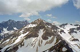
Soiernspitze
| Soiernspitze | |
|---|---|
 Soiernspitze | |
| Highest point | |
| Elevation | 2,257 m above sea level (NN) (7,405 ft) |
| Coordinates | 47°28′55″N 11°21′27″E / 47.48194°N 11.3575°ECoordinates: 47°28′55″N 11°21′27″E / 47.48194°N 11.3575°E |
| Geography | |
| Parent range | Karwendel (Soiern Group) |
| Geology | |
| Age of rock | Norian, Triassic |
| Mountain type | Plattenkalk[1] |
| Climbing | |
| Easiest route | Mittenwald – Seinsbachtal – Fereinalm – Soiernspitze |

At 2,257 metres, the Soiernspitze is the highest mountain in the Soiern Group in the Bavarian Karwendel range. Its summit may be climbed either from Seinsbachtal or from the Soiernhäusern by the lakes of Soiernseen in an easy mountain hike. The ridge walk to the nearby Schöttelkarspitze peak requires sure-footedness.

References
- ↑ Bayerisches Geologisches Landesamt, 1998, Geologische Karte von Bayern mit Erläuterungen 1:500000
External links
| Wikimedia Commons has media related to Soiernspitze. |
This article is issued from
Wikipedia.
The text is licensed under Creative Commons - Attribution - Sharealike.
Additional terms may apply for the media files.