Sŏhŭng County
| Sŏhŭng County 서흥군 | |
|---|---|
| County | |
| Korean transcription(s) | |
| • Hanja | 瑞興郡 |
| • McCune-Reischauer | Sŏhŭng-gun |
| • Revised Romanization | Seoheung-gun |
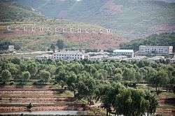 Poman-ri Fish Farm, Sohung County | |
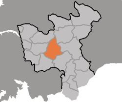 Map of North Hwanghae showing the location of Sohung | |
| Country | North Korea |
| Province | North Hwanghae Province |
| Area | |
| • Total | 566.14 km2 (218.59 sq mi) |
| Population (2008) | |
| • Total | 100,887 |
Sŏhŭng County is a county in North Hwanghae province, North Korea.
Administrative divisions
Sŏhŭng county is divided into 1 ŭp (town) and 20 ri (villages):
|
|
Transportation
Sŏhŭng county is served by the P'yŏngbu line of the Korean State Railway.

Coordinates: 38°25′35″N 126°10′05″E / 38.42639°N 126.16806°E
This article is issued from
Wikipedia.
The text is licensed under Creative Commons - Attribution - Sharealike.
Additional terms may apply for the media files.