Singye County
| Sin'gye County 신계군 | |
|---|---|
| County | |
| Korean transcription(s) | |
| • Hanja | 新溪郡 |
| • McCune-Reischauer | Sin’gye-kun |
| • Revised Romanization | Singye-gun |
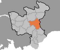 Map of North Hwanghae showing the location of Singye | |
| Country | North Korea |
| Province | North Hwanghae Province |
Sin'gye County is a county in North Hwanghae province, North Korea. It is a mining district with abandoned molybdenum and copper mines.[1]
Administrative divisions
Sin'gye county is divided into 1 ŭp (town) and 27 ri (villages):
|
|
Transport
Sin'gye county is served by three stations on the Ch'ŏngnyŏn Ich'ŏn line of the Korean State Railway.
References

This article is issued from
Wikipedia.
The text is licensed under Creative Commons - Attribution - Sharealike.
Additional terms may apply for the media files.