Soeste
| Soeste | |
|---|---|
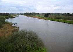 Soeste in Barßel | |
| Country | Germany |
| States | Lower Saxony |
| Physical characteristics | |
| River mouth |
Jümme 53°10′54″N 7°41′13″E / 53.1816°N 7.6870°ECoordinates: 53°10′54″N 7°41′13″E / 53.1816°N 7.6870°E |
| Basin features | |
| Progression | Jümme→ Leda→ Ems→ North Sea |
The Soeste is a river in the Cloppenburg district in Lower Saxony.
The Soeste forms from two source brooks in Hesselnfeld and Egterholz, two small settlements in the Emstek municipality. It flows northwest through Cloppenburg, where its water flow was already sufficient for water mills to be operated. The Soeste flows into a dam at Thülsfelde, which was built in the 1920s. From there it flows through the towns Friesoythe and Barßel. West of the latter town, the Soeste flows into the Jümme, which drains into the Ems.
Literature
- Heinz-Josef Lücking, 1995: Ökologische Bewertung des Soestetals zwischen Cloppenburg und Stedingsmühlen (LK Cloppenburg, Nordwest-Deutschland) aus der Sicht des Naturschutzes unter besonderer Berücksichtigung der Vegetation, Gewässergüte und des ökomorphologischen Gewässerzustandes. BSH/NVN n a t u r s p e c i a l R E P O R T ISBN 3-923788-29-0 Heft 21.
| Wikimedia Commons has media related to Soeste. |
This article is issued from
Wikipedia.
The text is licensed under Creative Commons - Attribution - Sharealike.
Additional terms may apply for the media files.