Sodam
| Sodam | |
|---|---|
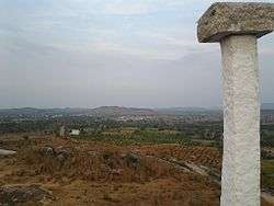 Aerial view of Sodam seen from Seethamma Gutta. | |
 Sodam Location in Andhra Pradesh, India | |
| Coordinates: 13°32′51″N 78°54′27″E / 13.54750°N 78.90750°ECoordinates: 13°32′51″N 78°54′27″E / 13.54750°N 78.90750°E | |
| Country | India |
| State | Andhra Pradesh |
| District | Chittoor |
| Mandal | Sodam |
| Government | |
| • Type | Panchayath |
| • Body | Sarpanch |
| Area | |
| • Total | 3.04 km2 (1.17 sq mi) |
| Population (2011) | |
| • Total | 6,995 |
| • Density | 2,300/km2 (6,000/sq mi) |
| Languages | |
| • Official | Telugu |
| Time zone | UTC+5:30 (IST) |
| PIN | 517123 |
| Vehicle registration | AP03 |
| Educational institutions | Srivinayaka public school |
Sodam is a mandal in Punganur constituency of Chittoor district in the southern Indian state of Andhra Pradesh.
References
| Wikimedia Commons has media related to Sodam. |
This article is issued from
Wikipedia.
The text is licensed under Creative Commons - Attribution - Sharealike.
Additional terms may apply for the media files.