Snover, Michigan
| Snover, Michigan | |
|---|---|
| Census-designated place | |
 Snover, Michigan  Snover, Michigan | |
| Coordinates: 43°27′40″N 82°58′15″W / 43.46111°N 82.97083°WCoordinates: 43°27′40″N 82°58′15″W / 43.46111°N 82.97083°W | |
| Country | United States |
| State | Michigan |
| County | Sanilac |
| Area[1] | |
| • Total | 6.874 sq mi (17.80 km2) |
| • Land | 6.873 sq mi (17.80 km2) |
| • Water | 0.001 sq mi (0.003 km2) |
| Elevation | 774 ft (236 m) |
| Population (2010)[1] | |
| • Total | 448 |
| • Density | 65/sq mi (25/km2) |
| Time zone | UTC-5 (Eastern (EST)) |
| • Summer (DST) | UTC-4 (EDT) |
| ZIP code | 48472 |
| Area code(s) | 810 |
| GNIS feature ID | 620195[2] |
Snover is an unincorporated community and census-designated place in Moore Township, Sanilac County, Michigan, United States. Its population was 448 as of the 2010 census.[1] Snover has a post office with ZIP code 48472.[3][4] The community was named for Horace G. Snover, who represented the area in Congress from 1895 to 1898.[5]
Geography
According to the U.S. Census Bureau, the community has an area of 6.874 square miles (17.80 km2), of which 6.873 square miles (17.80 km2) is land and 0.001 square miles (0.0026 km2) is water.[1]
References
- 1 2 3 4 "2010 Census Gazetteer Files - Places: Michigan". U.S. Census Bureau. Retrieved June 3, 2018.
- ↑ "Snover". Geographic Names Information System. United States Geological Survey.
- ↑ United States Postal Service. "USPS - Look Up a ZIP Code". Retrieved June 3, 2018.
- ↑ "Postmaster Finder - Post Offices by ZIP Code". United States Postal Service. Retrieved June 3, 2018.
- ↑ Romig, Walter (1986) [1973]. Michigan Place Names. Detroit, Michigan: Wayne State University Press. ISBN 0-8143-1838-X.
Municipalities and communities of Sanilac County, Michigan, United States | ||
|---|---|---|
| Cities | 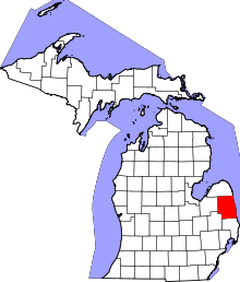 | |
| Villages | ||
| Townships | ||
| CDP | ||
| Other unincorporated communities | ||
| Footnotes | ‡This populated place also has portions in an adjacent county or counties | |
This article is issued from
Wikipedia.
The text is licensed under Creative Commons - Attribution - Sharealike.
Additional terms may apply for the media files.