Snoqualmie Tunnel
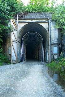 East portal at Hyak in 2006 | |
| Overview | |
|---|---|
| Location | Hyak, Washington |
| Coordinates | 47°23′41″N 121°23′47″W / 47.3947°N 121.3963°WCoordinates: 47°23′41″N 121°23′47″W / 47.3947°N 121.3963°W |
| Crosses |
Cascade Range, near Snoqualmie Pass |
| Operation | |
| Work begun | 1912 |
| Opened | 1914, 104 years ago |
| Operator | Milwaukee Road |
| Character |
Rail until 1980, now non-motorized trail |
| Technical | |
| Length | 2.2526 miles (3.625 km) |
| No. of tracks | Single |
| Track gauge | Standard |
| Electrified | Yes |
| Highest elevation | 2,600 feet (790 m) |


The Snoqualmie Tunnel is an abandoned railroad tunnel in the northwest United States, east of Seattle in the Cascade Range of Washington, about three miles (5 km) south of Snoqualmie Pass. At the border of King County and Kittitas County, the tunnel is 11,894 feet (2.253 mi; 3.625 km) in length.[1] Its east portal is at Hyak, close to exit 54 of Interstate 90, at an approximate elevation of 2,600 feet (790 m) above sea level, just north of Keechelus Lake.
The tunnel now serves as part of a rail trail in Iron Horse State Park. The trail is officially the John Wayne Pioneer Trail, but is commonly called the Iron Horse Trail.[2] It closed January 30, 2009 and reopened July 5, 2011 after renovations to the walls, ceiling, and path were completed.[3][4]
History
The tunnel was constructed from 1912–1914 by the Chicago, Milwaukee, St. Paul and Pacific Railroad ("The Milwaukee Road") as part of its line from Chicago to Seattle, completed in 1909. It replaced a temporary surface line over Snoqualmie Pass at 3,020 feet (920 m); this grade from Hyak to Rockdale later became U.S. Route 10, now the eastbound lanes of I-90. The tunnel is aligned east-west and electrification in 1917 eliminated smoke dissipation issues.
In 1980, the Milwaukee Road received approval from the Interstate Commerce Commission to abandon its lines west of eastern Montana. On March 15, 1980, the final Milwaukee Road train passed through the tunnel. Later, the State of Washington acquired the right-of-way for recreational use.
Today the tunnel is part of the Iron Horse State Park rails-to-trails project. It is usually closed between November 1 through early May due to ice formations inside the tunnel. On July 5, 2011 the tunnel re-opened after 11 months of renovations. The $700,000 renovation added a four-inch (10 cm) layer of concrete to the walls and ceiling, a reinforced structure, and a new and improved walking surface of crushed rock.[4]
Directions
From Seattle, take I-90 eastbound to exit #54 at Hyak, two miles (3 km) beyond Snoqualmie Pass. Turn right at the exit, then turn left at the stop sign. Follow the signs leading to Iron Horse State Park / Snoqualmie Tunnel and Keechelus Trail Head, then turn right before the highway maintenance area, then turn another right into the trailhead parking lot.
Gallery
 About 200 yards from exiting the west side of the Snoqualmie Tunnel
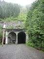 The west entrance to the Snoqualmie Tunnel
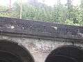 Snoqualmie Tunnel 1912-1914.
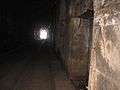
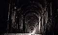 Inside the tunnel 2008.
See also
- Cascade Tunnel − Great Northern @ Stevens Pass
- Stampede Tunnel − Northern Pacific @ Stampede Pass
- St. Paul Pass Tunnel − (Idaho-Montana)
References
- ↑ Washington Geological Survey (1913). Bulletin - Washington Geological Survey, Issues 16-18. The Survey. p. 259. Retrieved 13 April 2017.
- ↑ Johnston, Greg (August 27, 2008). "Rolling on the old Milwaukee rail line". Seattle Post-Intelligencer. Retrieved January 9, 2017.
- ↑ Dolstad, Mackenzie. "Grand Re-opening of Snoqualmie Pass Tunnel". Mountains to Sound Greenway. Retrieved 8 June 2011.
- 1 2 Mapes, Lynda V. (July 6, 2011). "Snoqualmie Tunnel gives cyclists, riders cool new link". Seattle Times. Retrieved January 8, 2017.
External links
| Wikimedia Commons has media related to Snoqualmie Tunnel. |
- Washington State Parks - Iron Horse State Park Trail
- Snoqualmie History
- Study of Tunnels on Rail Trails
- Washington Trails Association - Iron Horse tunnel