Snaefell mountain road
| |
|---|---|
.png) | |
| Route information | |
| Length | 13.35 mi (21.48 km) |
| Major junctions | |
| North end |
Ramsey 54°19′14″N 4°23′06″W / 54.32056°N 4.38500°W |
| South end |
Governor's Bridge, Douglas 54°10′18″N 4°28′06″W / 54.17167°N 4.46833°W |
| Road network | |

The A18 Snaefell Mountain Road[1][2] or Mountain Road[3] (Manx: Giat y Clieau)[4] is a primary main A-road of 13.35 miles (21.48 km) in length[5] which connects the towns of Douglas and Ramsey in the Isle of Man.
Description
The Mountain Road is part of Isle of Man TT Mountain Course or Mountain Course,[6] a road-racing circuit used for the Isle of Man TT and Manx Grand Prix races, which have been held in the Isle of Man from 1911 and 1923 respectively. In the races, it is one-way from Ramsey towards Douglas. The racing is held on public roads closed for racing by an Act of Tynwald (the parliament of the Isle of Man). It is the oldest motor-cycle racing circuit still in use. The highest point of the course is on the A18 Snaefell Mountain Road between the Bungalow and Hailwood's Height at Ordnance Survey spot height 422 metres (1,385 feet) above sea level, with gradients reaching 14%.
The A18 Snaefell Mountain Road was described in the publication Classic Motor-Sport Routes as:[7]
| “ |
....you'll notice that once you get beyond Ramsey and the tight left hand hairpin bend to begin the climb onto the Mountain Road, most Manx drivers don't tend to hang about. The sense of freedom given by the liberal road traffic laws and the brooding, mountain and moorland terrain makes driving here an invigorating experience.... |
” |
Route
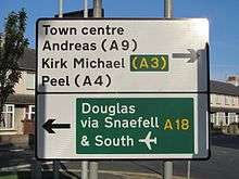
The A18 Snaefell Mountain Road runs from the A2 Governor's Road at Governor's Bridge in Douglas north to Ramsey, and includes the A18 Bemahague Road from Governor's Bridge to Signpost Corner. As part of the Snaefell Mountain Course, in reverse direction it passes through Cronk-ny-Mona, Hillberry Corner and the junction with the C22 Little Mill Road, Brandish Corner, Creg-ny-Baa, Kate's Cottage, Keppel Gate, Windy Corner and the B10 Sartfield Road road junction with Brandywell. Continuing north, the A18 Mountain Road passes over the Snaefell Mountain Railway tramway crossing at the Bungalow and the A14 Sulby Glen Road, Bungalow Bridge, Verandah, Stonebreakers Hut, East Mountain Gate, Mountain Box, the Mountain Mile including Guthrie's Memorial, 26th Milestone, the D28 Hibernia Road junction at the Gooseneck, Water Works Corner, Ramsey Hairpin and Whitegates. The A18 Snaefell Mountain Road at its northern end includes two small sections of road previously held in private ownership between Cruickshank's Corner and the road junctions with the A9 Ramsey to Andreas Road and the A2 Douglas to Ramsey Road situated in the town of Ramsey.
Origins and History
The A18 Snaefell Mountain Road was developed in the mid-19th century from a number of pre-existing roads, cart-tracks and bridle paths. This included installation of a number of sheep-gates including the East Mountain Gate, the Beinn-y-Phott sheep-gate at Brandywell and Keppel Gate.[8] The section of the A18 Snaefell Mountain Road from Keppel Gate northwards to the Gooseneck corner near Ramsey was built on common grazing land that was transferred to the Crown following the sale of the Island's feudal rights by the Duke of Atholl after the Disafforesting Commission of 1860.[9]
As the A18 Snaefell Mountain Road is purpose-built, it reflects typical 19th century highway and railway construction practices, with many small-scale cuttings, embankments and revetments, and follows land contours with purpose-built graded sections intersected by right-angle bends, road junctions and sheep-gates.[10]
Milestones
The A18 Snaefell Mountain Road has small metal milestones[11] from the period of James Garrow as Isle of Man Surveyor-General;[12] they are numbered numerically from Douglas to Ramsey.
National Geographic Top 10 Drives
In 2014, the National Geographic magazine nominated the A18 Snaefell Mountain Road as No 8 in the Top 10 Driver's Drives. [13]
| “ |
No 8. A18 Snaefell Mountain Road – The Isle of Man has been a leading motorsport destination since 1904, when racing was legalized on public roads. This 15-mile route between Douglas and Ramsey is the motorcycle-racing circuit used for the Isle of Man TT (Tourist Trophy) and the Manx Grand Prix. The road skirts the peak of Snaefell, the tallest mountain on the island at 2,035 feet (sic). A key attraction for many: The Isle of Man is one of the few British territories with no national speed limit." |
” |
Sources
- ↑ Isle of Man Examiner page 33 dated 8 July 2008
- ↑ Government Circular No 169/78 page 1&3 SCHEDULE PART I The Manx International Trophy Rally Order 1978 W. H. VINCENT SECRETARY (1978) Isle of Man Highway and Transport Board. 4 August 1978 "1. ABBEYLANDS, EAST BALDWIN, INJEBRECK, BRANDYWELL 9.30 a.m. - 12.30 p.m. The Scholague Road from its junction with the A.18 Snaefell Mountain Road to Abbeylands crossroads...."
- ↑ Government Circular No 71/77 page 1&2 The Regulation of Traffic (T.T. Races) Order 1977 W. H. VINCENT SECRETARY (1977) Isle of Man Highway and Transport Board. 25 March 1977 "....commonly known as the Mountain Road...."
- ↑ SLIABH (SLIEAU) IN MAN pages 1 to 6 George Broderick (2003) University of Mannheim "3. Moors or areas of upland Giat y Clieau LE SC4189 (roadway-name from adjacent moor) ‘the mountain road’ (geata an t-sléibhe)."
- ↑ Government Circular No. 1131. pages 1 to 4 Main Roads B. E. SARGEAUNT, Government Secretary Government Office, Isle of Man 25 February, 1926
- ↑ Isle of Man Centenary TT – ACU/MMCC Official Race Guide pp67 Isle of Man Department of Tourism and Leisure (2007) Mannin Media Group Ltd
- ↑ Classic Motor-Sport Routes page 57 by Richard Meaden 1st Edition (2007) AA Publishing Ltd ISBN 978-0-7495-5225-1 Oriental Press Dubai
- ↑ Isle of Man Examiner page 5 dated 5 June 1969
- ↑ The Isle of Man by Train, Tram and by Foot page 57 by Stan Basnett (1990) Lily Publications ISBN 1-899602-72-0 Walk 10 - Abbeylands and Nobles Park to Laxey
- ↑ Manx Milestones pages 13–17 and pages 57–58 by Stuart Slack (1st Edition)(2003)The Manx Experience ISBN 1-873120-58-3
- ↑ Manx Milestones by Stuart Slack pp56-57 (1st Edition)(2003)The Manx Experience ISBN 1-873120-58-3
- ↑ Isle of Man Examiner dated 3 May 1913
- ↑ "National Geographic Top 10 Drivers' Drives". National Geographic Online. Retrieved 22 November 2014.
External links
Route map: