Smoke Bend, Louisiana
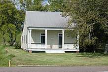
Rome House, on Louisiana Highway 1, northeast of intersection with Delaney Road
Smoke Bend is an unincorporated community in Ascension Parish, Louisiana, United States.[1][2]
A small cottage from the 1870s named Rome House, listed on the National Register of Historic Places, is located here.[3][4]
It is located: Latitude: 30.10833 Longitude: -91.02028 Elevation: 22 ft
Notable person
- Earl Ernest Veron - United States federal judge
References
- ↑ "placenames". www.placenames.com. Archived from the original on 2012-08-06.
- ↑ "Smoke Bend, LA - Smoke Bend, Louisiana Map & Directions - MapQuest". www.mapquest.com.
- ↑ http://crt.louisiana.gov/hp/nationalregister/nhl/search_results.asp?search_type=city&value=Smoke+Bend&pageno=1%5Bpermanent+dead+link%5D
- ↑ http://www.crt.state.la.us/hp/nationalregister/nhl/parish03/scans/03014001.pdf%5Bpermanent+dead+link%5D
Municipalities and communities of Ascension Parish, Louisiana, United States | ||
|---|---|---|
| Cities | 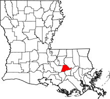 | |
| Town | ||
| CDPs | ||
| Other unincorporated communities |
| |
| Footnotes | ‡This populated place also has portions in an adjacent parish or parishes | |
Coordinates: 30°06′31″N 91°01′13″W / 30.10861°N 91.02028°W
This article is issued from
Wikipedia.
The text is licensed under Creative Commons - Attribution - Sharealike.
Additional terms may apply for the media files.