Smackover Formation
| Smackover Formation Stratigraphic range: Oxfordian | |
|---|---|
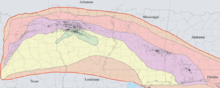 Wells reporting Smackover Formation tops are indicated by a black point, and extend from Texas to Florida. Formation top depths measured in 6,764 wells range from 1,394 to 23,554 feet. | |
| Type | Formation |
| Underlies | Buckner Formation |
| Overlies | Norphlet Formation |
| Location | |
| Region | Arkansas |
| Country | United States |
The Smackover Formation is a geologic formation in Arkansas. It preserves fossils dating back to the Jurassic period.
The Smackover Formation consists of oolitic limestones and silty limestones.[1][2]
Mineral resources
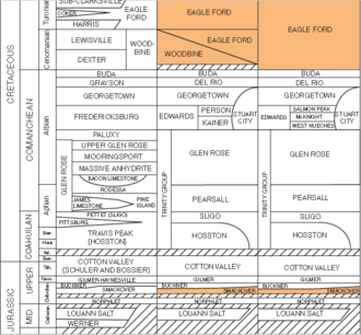
Smackover Formation stratigraphic column for Texas
The Smackover Formation has been a prolific source of petroleum. The 1922 discovery of the Smackover oil field, after which the Smackover Formation is named, resulted in a sizeable oil boom in southern Arkansas.
In addition to being a petroleum reservoir, as of 2015, the brine from the Smackover Formation is the only source of commercial bromine in the United States.[3]
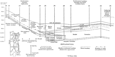
Smackover and Bossier Formations geologic cross section
See also
References
- ↑ Dickinson, Kendell (1968). Upper Jurassic Stratigraphy of Some Adjacent Parts of Texas, Louisiana, and Arkansas. USGS. p. E9.
- ↑ Chimene, Calvin (1976). Braunstein, Jules, ed. Upper Smackover Reservoirs, Walker Creek Field Area, Lafayette and Columbia Counties, Arkansas, in North American Oil and Gas Fields. Tulsa: The American Association of Petroleum Geologists. pp. 177–204. ISBN 0891813004.
- ↑ Various Contributors to the Paleobiology Database. "Fossilworks: Gateway to the Paleobiology Database". Archived from the original on 31 July 2014. Retrieved 8 July 2014.
This article is issued from
Wikipedia.
The text is licensed under Creative Commons - Attribution - Sharealike.
Additional terms may apply for the media files.