Smědá
| Smědá | |
|---|---|
 | |
| Country | Czech Republic, Poland |
| Physical characteristics | |
| Main source |
Jizera Mountains 847 m (2,779 ft) 50°50′36″N 15°16′27″E / 50.84333°N 15.27417°E |
| River mouth |
Nysa Łużycka, Radomierzyce 51°02′59″N 14°57′51″E / 51.04972°N 14.96417°ECoordinates: 51°02′59″N 14°57′51″E / 51.04972°N 14.96417°E |
| Length | 51.9 km (32.2 mi) |
| Basin features | |
| Progression | Lusatian Neisse→ Oder→ Baltic Sea |
| Basin size | 331 km2 (128 sq mi) |
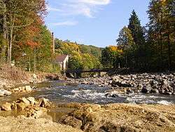
The Smědá (Czech pronunciation: [ˈsmɲɛdaː], German: Wittig, Polish: Witka) is a river of the Czech Republic and Poland. A right tributary of the Neisse River with a length of 51.9 km (5.9 km within Poland) and basin area 331 km² (60 km² in Poland).[1]
The river flows out of the three streams in the Jizera Mountains: Bílá Smědá, Černá Smědá, and Hnědá Smědá, in the Czech Republic. The main of those is considered Bílá Smědá emerging from the peat bogs between Smědavská and Jizera mountains. From the village of Ostróżno to the mouth of the stream Boreczek it is a border river, flows through Niedów Lake (Witka Lake), and escapes to the Neisse River next to the palace in the village Radomierzyce.
The final section of the river within the limits of the Czech Republic creates a nature reserve Smědé Meanders (Witka Meanders) to protect the natural landscape of the river valley, rich vegetation and wetland meanders riparian forests.
In Poland the name Witka was officially introduced in 1951, replacing the German name Wittig.
Tributaries
|
|
Notes and references
- ↑ Předlánce – aktuální vodní stav. Tok: Smědá Českého hydrometeorologického ústavu, 2011.