Solotvyno
| Solotvyno | ||
|---|---|---|
| Urban-type settlement | ||
| ||
 Solotvyno | ||
| Coordinates: 47°57′20″N 23°52′16″E / 47.95556°N 23.87111°ECoordinates: 47°57′20″N 23°52′16″E / 47.95556°N 23.87111°E | ||
| Country |
| |
| Oblast | Zakarpattia Oblast | |
| Raion | Tiachiv Raion | |

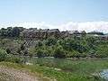
Solotvyno (Ukrainian: Солотвино, Hungarian: Aknaszlatina, Romanian: Slatina, Rusyn: Солотвино, Yiddish: סלאטפינא, Slovak: Slatinské Doly) is an urban-type settlement in Tiachiv Raion in Zakarpattia Oblast of Ukraine, located close to the border with Romania, on the right bank of the Tisza River (across from the Romanian city of Sighetu Marmaţiei). The village's name comes from the nearby salt mine (sol’ (соль) in Russian means salt).
Solotvyno was first mentioned ca. 1360 (the former one was burned down by the Tatars in 1241). Population: 8,791 (2016 est.)[1].
Notable residents
- It was the birthplace of the late British press mogul Robert Maxwell.[2][3]
Gallery
.jpg) A salt mine in the town of Solotvyno
A salt mine in the town of Solotvyno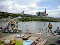 Recreation camp, "El dorado"
 Underground office of the hospital
%2Cformer_synagogue.jpg) Former synagogue
Former synagogue Former synagogue, now bakery
%2Cold_jewish_cemetery.jpg) Old Jewish cemetery
Old Jewish cemetery%2Cnew_jewish_cemetery.jpg) New Jewish cemetery
New Jewish cemetery%2CJewish_memorial_plaque.jpg) Jewish memorial plaque
Jewish memorial plaque
See also
References
- ↑ "Чисельність наявного населення України (Actual population of Ukraine)" (PDF) (in Ukrainian). State Statistics Service of Ukraine. Retrieved 19 July 2016.
- ↑ Марк Штейнберг. Евреи в войнах тысячелетий. p. 227. ISBN 5-93273-154-0 (in Russian)
- ↑ Иван Мащенко (September 7–13, 2002). Медиа-олигарх из Солотвина. Зеркало недели (in Russian) (#34 (409)). Archived from the original on 2012-12-22.
External links
| Raions | |||||
|---|---|---|---|---|---|
| Cities |
| ||||
| |||||
This article is issued from
Wikipedia.
The text is licensed under Creative Commons - Attribution - Sharealike.
Additional terms may apply for the media files.