Skull Valley (Utah)
| Skull Valley (Utah) | |
| Valley | |
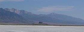 View south-southeast, from Timpie area (northeast valley at Stansbury Mountains from Great Salt Lake (saltflats)) | |
| Country | United States |
|---|---|
| State | Utah |
| County | Tooele |
| Borders on | Cedar Mountains, Lakeside Mountains, Stansbury Bay (Great Salt Lake), Stansbury Mountains, Onaqui Mountains, Dugway, Great Salt Lake Desert |
| Communities | Iosepa, Terra, Dugway, Delle, Timpie |
| Springs (south valley) |
Willow Patch Springs & Scribner Spring |
| Coordinates | 40°32′14″N 112°44′40″W / 40.53722°N 112.74444°WCoordinates: 40°32′14″N 112°44′40″W / 40.53722°N 112.74444°W |
| Length | 40 mi (64 km), N–S |
| Width | 12 mi (19 km), (varies, 7–12 mi, narrows in southeast at springs) |
 Skull Valley in Utah | |
Skull Valley, is a 40-mile (64 km) long[1] valley located in east Tooele County, Utah, United States at the southwest of the Great Salt Lake.[2] The valley trends north–south, but turns slightly northeast to meet Stansbury Bay, (adjacent Stansbury Island).
Skull Valley's south and southwest borders the southeast Great Salt Lake Desert at Dugway and at a ridgeline southeast from the Cedar Mountains.
The Skull Valley Indian Reservation is located in the valley's south at the southwest foothills of the Stansbury Mountains; adjacent southeast, the valley narrows between the Stansbury Mountains, and the Cedar Mountains at west, a region of creeks from the Stansburys and valley springs, Willow Patch Springs and Scribner Spring. Creeks and springs from the northwest Onaqui Mountains also feed the southeast valley region.
Description
Skull Valley trends north–south, but narrows slightly northeast towards Stansbury Bay; the Lakeside Mountains at Delle, and the northwest Stansbury Mountains at Timpie form the narrowing of the valley; Skull Valley and sections of the mountain ranges form the Great Salt Lake's southwest border.
Skull Valley narrows southeastwards at the springs, as described. Bordering southwest here, is a southeast trending 16 mi[3] long ridgeline from the west perimeter Cedar Mountains, which separates the Dugway Proving Grounds and the Great Salt Lake Desert region from the southwest Skull Valley.
The center of the valley is adjacent west of Iosepa. A dissected region of sinks and floodland from neighboring washes and creeks form this valley center; this dissected floodland area is about 4 mi at its widest southwest of Iosepa, and extends 7 mi[3] northwards towards the beginning of areas of salt flats, associated with the Great Salt Lake.
 View south from Iosepa, Stansbury Mountains east
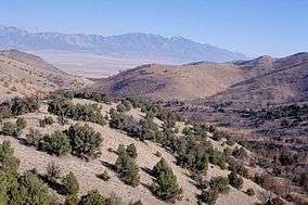 Southeast view of west Stansburys (over central Skull Valley), from Cedar Mountain Wilderness, in the Cedar Mountains
See also
References
- ↑ Utah, DeLorme Atlas & Gazetteer, pp. 15 & 16, 23 & 24.
- ↑ U.S. Geological Survey Geographic Names Information System: Skull Valley (Utah)
- 1 2 DeLorme Atlas, pp. 23, 24.
External links
![]()