Sklithro, Florina
| Sklithro Σκλήθρο | |
|---|---|
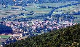 Sklithro in summer 2005 | |
 Sklithro | |
| Coordinates: 40°37′N 21°30′E / 40.617°N 21.500°ECoordinates: 40°37′N 21°30′E / 40.617°N 21.500°E | |
| Country | Greece |
| Administrative region | West Macedonia |
| Regional unit | Florina |
| Municipality | Amyntaio |
| Municipal unit | Aetos |
| Elevation | 680 m (2,230 ft) |
| Community[1] | |
| • Population | 532 (2011) |
| Time zone | UTC+2 (EET) |
| • Summer (DST) | UTC+3 (EEST) |
| Postal code | 530 75 |
| Area code(s) | 23860 |
Sklithro (Greek: Σκλήθρο, before 1927: Ζέλενιτς - Zelenits;[2] Bulgarian and Macedonian Slavic: Зелениче, Zeleniche)[3][4][5] is a small village located about 40 kilometres southwest of Florina, the capital of Florina regional unit in northwestern Greece. It is situated in a valley at the foot of the Vitsi mountain range halfway along the Amyntaio – Kastoria local road.
Sklithro is currently inhabited by 532 permanent residents (2011 census).[1]
History
In 1845 the Russian slavist Victor Grigorovich recorded Zelenich as mainly Bulgarian village.[6]
At its peak in the first part of the twentieth century, the population of the village had reached about 3,500 inhabitants. There were two Bulgarian and one Greek school in the village in the beginning of 20th century.[7] The population decrease can be attributed to many causes including World War I, the population exchange with Turkey following the Treaty of Lausanne, World War II, as well as the Greek Civil War which affected Sklithro and the surrounding region. Following the Civil War, the village saw an exodus of people migrating to North America, Australia, and other European countries, where opportunity and a better way of life existed. Today, the village is experiencing a bit of a rejuvenation. Many of the formerly abandoned homes have been or are in the process of being renovated. Agriculture continues to be the mainstay of the village and is celebrated with an annual potato festival in the month of August. During the summer months tourism also plays an important role, with visitors including former residents or their decedents. Also, nearby are the tourist attractions of Nymfaio and the Arcturos bear refuge.
References
- 1 2 "Απογραφή Πληθυσμού - Κατοικιών 2011. ΜΟΝΙΜΟΣ Πληθυσμός" (in Greek). Hellenic Statistical Authority.
- ↑ Name changes of settlements in Greece
- ↑ Григорович, В. Очеркъ путешествiя по Европейской Турцiи, Москва, 1877, стр. 93.
- ↑ Верковичъ, С.И. „Топографическо-этнографическiй очеркъ Македонiи“. СПб, 1889, стр. 154.
- ↑ Васил Кънчов. „Македония. Етнография и статистика“. София, 1900, стр. 250.
- ↑ Григорович, В. Очеркъ путешествiя по Европейской Турцiи, Москва, 1877 "...населено преимущественно Болгарами с примесью Валахов и Турков. Поименую села их: Владово, Острово, Кочено, Кадрево, Гугово, Русилово, Дружко, Ослово, Пачетин, Ниссие, Чегано, Крмско, Учин, Грамматиново, Ракита, Каменек, Баината, Орево, Жерве, Петерско у озера, Рошава, Пътеле, Суровичево, Гулинци, [93] Любетино, Зеленич, Палиора, Дебрец, Невеска и Судир (в обоих сел. Влахи), Вербини, еще Вербини, Црево, Баньци, Забердин, Вуштарни, Крушораде, Ситина, Совиче, Добровина, Бачь, Куйнавите, Ромалия, Саново село, Секулево, Кальник, Клештина, Арминор, Кодорево, Клобучище, Арменско, Неволино, Лежини, Кучковини, Пешошница, Вартолом, Лесковец..."
- ↑ D.M.Brancoff. "La Macedoine et sa Population Chretienne". Paris, 1905, p.176-177.