Skjervøy (village)
| Skjervøy | |
|---|---|
| Village | |
 View of the village | |
 Skjervøy Location in Troms  Skjervøy Skjervøy (Norway) | |
| Coordinates: 70°01′52″N 20°58′17″E / 70.03111°N 20.97139°ECoordinates: 70°01′52″N 20°58′17″E / 70.03111°N 20.97139°E | |
| Country | Norway |
| Region | Northern Norway |
| County | Troms |
| District | Nord-Troms |
| Municipality | Skjervøy Municipality |
| Area[1] | |
| • Total | 1.29 km2 (0.50 sq mi) |
| Elevation[2] | 7 m (23 ft) |
| Population (2017)[1] | |
| • Total | 2,460 |
| • Density | 1,907/km2 (4,940/sq mi) |
| Time zone | UTC+01:00 (CET) |
| • Summer (DST) | UTC+02:00 (CEST) |
| Post Code | 9180 Skjervøy |
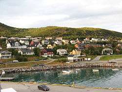
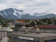
Skjervøy is the administrative centre in Skjervøy Municipality in Troms county, Norway. The village is located on the island of Skjervøya along the Kvænangen, near the mouth of the Reisafjorden. The 1.29-square-kilometre (320-acre) village has a population (2017) of 2,460 which gives the village a population density of 1,907 inhabitants per square kilometre (4,940/sq mi).[1]
View of the village
The village's economy is based on the fishing industry. It is a stop on the Hurtigruten express boats. The historic Skjervøy Church is located in this village. The village is connected to the mainland by the Skattørsundet Bridge (which connects to Kågen island) and then the Maursund Tunnel (which connects Kågen to the mainland).[3]
References
- 1 2 3 Statistisk sentralbyrå (1 January 2017). "Urban settlements. Population and area, by municipality".
- ↑ "Skjervøy" (in Norwegian). yr.no. Retrieved 2012-12-23.
- ↑ Store norske leksikon. "Skjervøy – tettstedet" (in Norwegian). Retrieved 2012-12-23.
| Authority control |
|---|
This article is issued from
Wikipedia.
The text is licensed under Creative Commons - Attribution - Sharealike.
Additional terms may apply for the media files.