Skid Hill
| Skid Hill | |
|---|---|
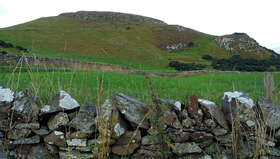 Skid Hill seen from NW | |
| Highest point | |
| Elevation | 186 m (610 ft) [1] |
| Prominence | 98[2] |
| Listing | TuMP[2] |
| Coordinates | 55°58′42″N 2°47′30″W / 55.97838°N 2.79170°WCoordinates: 55°58′42″N 2°47′30″W / 55.97838°N 2.79170°W |
| Geography | |
 Skid Hill | |
| Parent range | Garleton Hills |
| OS grid | NT 50730 76437 [3] |
Skid Hill is a 186 metres high hill of eastern Scotland, the highest of the Garleton Hills[1].
Geology
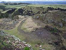
The old quarry
The hill origin is volcanic and it shows both trachitic and basic lavas, recognisable thanks to the excavations connected to the disused quarry opened in its eastern flanks[4].
History
A hill fort was detected close to the top of Skid Hill, in one area now located on the northern edge of the disused quarry[5].
Access to the summit
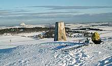
Skid Hill trig point in winter
Very close to the actual summit of Skid Hill stands a trig point[2]. It can be easily accessed on foot from a road flanking the hill by a good track running along the South side of the hill and then by cattle tracks on its western side.[3]
See also
References
- 1 2 Munro, David M. (2006). Scotland: An Encyclopedia of Places & Landscapes. Collins. p. 219. Retrieved 2018-09-04.
- 1 2 3 "Skid Hill". Retrieved 2018-09-04.
- 1 2 "TP6000 - Skid Hill". Retrieved 2018-09-04.
- ↑ Craig, Gordon Younger; McLaren Donald Duff, Peter (1975). The Geology of the Lothians and south east Scotland: an excursion guide. Edinburgh Geological Society, Scottish Academic Press Ltd. p. 72. Retrieved 2018-09-04.
- ↑ Maxwell, Herbert (1924). Eighth report with inventory of monuments and constructions in the county of East Lothian. Royal Commission on the Ancient and Historical Monuments and Constructions of Scotland. p. 2. Retrieved 2018-09-04.
External links
![]()
- Description of the hill fort on ancientmonuments.uk
This article is issued from
Wikipedia.
The text is licensed under Creative Commons - Attribution - Sharealike.
Additional terms may apply for the media files.