Sirinhaém
| Sirinhaém | |||
|---|---|---|---|
| Municipality | |||
| The Municipality of Sirinhaém | |||
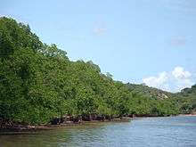
 Santo Aleixo island | |||
| |||
 Location in Pernambuco | |||
 Sirinhaém Location in Brazil | |||
| Coordinates: 8°35′41″S 35°06′50″W / 8.59472°S 35.11389°WCoordinates: 8°35′41″S 35°06′50″W / 8.59472°S 35.11389°W | |||
| Country |
| ||
| Region | Northeast | ||
| State |
| ||
| Founded | June 12, 1614 | ||
| Government | |||
| • Mayor | Franz Araujo Hacker (PSD) | ||
| Area | |||
| • Total | 378.790 km2 (146.252 sq mi) | ||
| Elevation | 49 m (161 ft) | ||
| Population (2013) | |||
| • Total | 43,036 | ||
| • Density | 110/km2 (290/sq mi) | ||
| [1] | |||
| Time zone | UTC-3 (UTC-3) | ||
| Postal Code | 55580-000 | ||
| HDI (2010) | 0.597 – low[2] | ||


Sirinhaém is a municipality in Pernambuco with 43,036 inhabitants. The town was founded in 1614 making it among the oldest in the state. The Prefeito is Franz Araujo Hacke of the PSD.
Access
BR-101, PE-060, PE-064 (via Cabo de Santo Agostinho)
Geography
- State - Pernambuco
- Region - RMR (Recife)
- Boundaries - Ipojuca and Escada (N); Rio Formoso and Tamandaré (S); Ribeirão (W); Atlantic Ocean (E)
- Area - 378.8 km2
- Elevation - 49 m
- Vegetation - Forest Subperenifólia and Coconut trees
- Climate - Hot tropical and humid
- Mean and high annual temperatures - 20.1 °C; 29.5 °C
- Distance to Recife - 65 km
Beaches
- Gamela beach
Beach of clear water, reefs and extensive areas of coconut trees. It has some bars and Palhoças (tents) offering typical food of the region (based in fish and seafood).
- Guadalupe beach
Still almost virgin in its 3 kilometers long. Its part of the Gold Coast Project, created to develop in a planned and environmentally way the potential of one extensive coast area since Cabo de Santo Agostinho until Maragogi in Alagoas.
- Barra de Sirinhaém beach
Fluvial - marine beach, is largely used to practice water sports. With six kilometers long, has several sections where bathing is not recommended, due to the violence of the waves.
- Ilha de Santo Aleixo - Sirinhaém
Economy
The main economic activities in Sirinhaém are based in food and beverage industry, commerce, some tourism and agriculture especially coconuts.
Economic indicators
| Population [3] | GDP x(1000 R$).[4] | GDP pc (R$) | PE |
|---|---|---|---|
| 43.036 | 183.646 | 4.817 | 0.28% |
Economy by Sector, 2008
| Primary sector | Secondary sector | Service sector |
|---|---|---|
| 17,33% | 27.23% | 55.43% |
Health indicators
| HDI (2010) | Hospitals (2007) | Hospitals beds (2007) | Children's Mortality every 1000 (2005) |
|---|---|---|---|
| 0.597 | 3 | 98 | 25 |
Distances from Sirinhaém
| São Paulo 2069 km | Rio de Janeiro 1813 km | Salvador, Bahia 613 km | |
| Brasília 1607 km | Fortaleza 662 km | Belo Horizonte 1571 km | |
| Curitiba 2401 km | Manaus 2824 km | Recife 65 km mais próxima | |
| Porto Alegre 2918 km | Belém 1683 km | Goiânia 1779 km |
References
- ↑ 3=Censo Populacional 2013. Instituto Brasileiro de Geografia e Estatística (IBGE) (setembro de 2013).
- ↑ - UNDP
- ↑ 3=Censo Populacional 2013. Instituto Brasileiro de Geografia e Estatística (IBGE) (setembro de 2013).
- ↑ Sirinhaem 2007 GDP IBGE page 32 Archived 2016-03-04 at the Wayback Machine.
- ↑ PE State site - City by city profile