Sinnemahoning, Pennsylvania
| Sinnemahoning, Pennsylvania | |
|---|---|
| Unincorporated community | |
 Sinnemahoning  Sinnemahoning | |
| Coordinates: 41°19′09″N 78°05′47″W / 41.31917°N 78.09639°WCoordinates: 41°19′09″N 78°05′47″W / 41.31917°N 78.09639°W | |
| Country | United States |
| State | Pennsylvania |
| County | Cameron |
| Elevation | 801 ft (244 m) |
| Time zone | UTC-5 (Eastern (EST)) |
| • Summer (DST) | UTC-4 (EDT) |
| ZIP code | 15861 |
| Area code(s) | 814 |
| GNIS feature ID | 1187723[1] |
Sinnemahoning, also known as Sinnamahoning, is an unincorporated community in Cameron County, Pennsylvania, United States.[1] The community is located along Sinnemahoning Creek and Pennsylvania Route 120 2.4 miles (3.9 km) southeast of Driftwood. Sinnemahoning has a post office with ZIP code 15861.[2][3]
References
- 1 2 "Sinnemahoning". Geographic Names Information System. United States Geological Survey.
- ↑ United States Postal Service. "USPS - Look Up a ZIP Code". Retrieved April 5, 2015.
- ↑ "Postmaster Finder - Post Offices by ZIP Code". United States Postal Service. Retrieved April 5, 2015.
Municipalities and communities of Cameron County, Pennsylvania, United States | ||
|---|---|---|
| Boroughs | 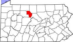 | |
| Townships | ||
| CDP | ||
| Unincorporated communities | ||
This article is issued from
Wikipedia.
The text is licensed under Creative Commons - Attribution - Sharealike.
Additional terms may apply for the media files.