Singleshot Mountain
| Singleshot Mountain | |
|---|---|
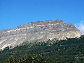 Singleshot Mountain high point at far left with Napi Rock at right | |
| Highest point | |
| Elevation | 7,930 ft (2,420 m) [1] |
| Prominence | 206 ft (63 m) [1] |
| Coordinates | 48°44′29″N 113°29′50″W / 48.74139°N 113.49722°WCoordinates: 48°44′29″N 113°29′50″W / 48.74139°N 113.49722°W [2] |
| Geography | |
 Singleshot Mountain | |
| Parent range | Lewis Range |
| Topo map | USGS Saint Mary MT |
| Climbing | |
| First ascent | Unknown |
| Easiest route | Hike |
Singleshot Mountain (7,930 feet (2,417 m)) is located in the Lewis Range, Glacier National Park in the U.S. state of Montana.[3] The mountain is easily seen from Saint Mary, Montana and was named after the single-shot fired from a rifle by George Bird Grinnell when dispatching a Bighorn sheep while hunting for food in 1885 during park explorations.[4] The sedimentary layers of the Appekunny Formation are clearly displayed on the southeastern cliffs of Singleshot Mountain.
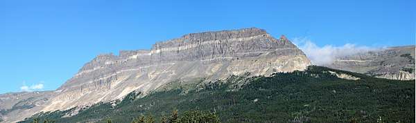
Wide view of Singleshot Mountain
See also
References
- 1 2 "Singleshot Mountain, Montana". Peakbagger.com. Retrieved May 27, 2018.
- ↑ "Singleshot Mountain". Geographic Names Information System. United States Geological Survey. Retrieved May 27, 2018.
- ↑ Saint Mary, MT (Map). TopoQwest (United States Geological Survey Maps). Retrieved May 27, 2018.
- ↑ Moravek, Vince (January 14, 2014). It Happened in Glacier National Park (2nd ed.). Globe Pequot. p. 13. ISBN 9781493006908. Retrieved May 27, 2018.
This article is issued from
Wikipedia.
The text is licensed under Creative Commons - Attribution - Sharealike.
Additional terms may apply for the media files.