Simiutaq Island
| Nickname: Cruncher Island | |
|---|---|
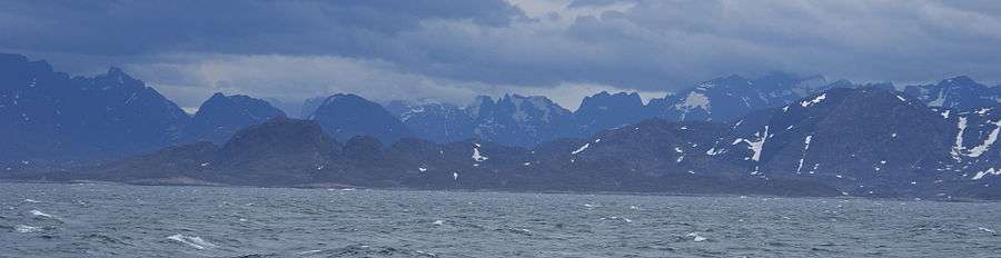
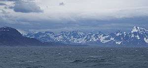 Southern end of Simiutaq Island at the mouth of Kangerlussuaq Fjord | |
 Simiutaq | |
| Geography | |
| Location | Davis Strait |
| Coordinates | 66°04′00″N 53°32′30″W / 66.06667°N 53.54167°WCoordinates: 66°04′00″N 53°32′30″W / 66.06667°N 53.54167°W |
| Administration | |
|
Greenland | |
| Municipality | Qeqqata |
Simiutaq Island is a 13 km × 10 km (8.1 mi × 6.2 mi) uninhabited island in the Qeqqata municipality in western Greenland, located in the mouth of the long Kangerlussuaq Fjord.[1] For the former U.S. radio station there, see Simiutak.
Supply ships of Royal Greenland and cruise ships, such as Norway's Hurtigruten[2] sail into Kangerlussuaq Fjord south of the island. The fjord is navigable in its entire length, with the ships mooring at the Kangerlussuaq port, west of Kangerlussuaq Airport.[3] There are several small skerries in the mouth of the fjord, at the southern end of Simiutaq Island.
Geography
The island is located on the shores of Davis Strait, separated from the mainland by the Amerluunguaq Strait in the north, and by the main arm of the Kangerlussuaq Fjord in the southeast.[1]
Simiutaq is not an outlying island; it would have been a continuation of the landmass in the north were it not for the narrow and shallow Amerlunnguaq Strait, which branches to the west off Kangerlussuaq Fjord near the mouth of the latter. Simiutaq is roughly triangular in shape, mostly hilly, with low undulading plain in the north, and the highest point at 775 m (2,542.7 ft).[1]
Promontories
| Direction | Latitude N | Longitude W |
|---|---|---|
| Northwestern Cape | 66°05′10″ | 53°40′45″ |
| Eastern Cape | 66°04′43″ | 53°24′13″ |
| Southern Cape | 66°01′29″ | 53°34′00″ |
Settlement
The closest settlement is Kangaamiut, located on a small island on the shores of Davis Strait, approximately 26 km (16 mi) south of the island.
References
| Wikimedia Commons has media related to Simiutaq Island. |
- 1 2 3 Maniitsoq, Saga Map, Tage Schjøtt, 1992
- ↑ Hurtigruten.co.uk Archived 2010-05-09 at the Wayback Machine.
- ↑ sisimiut.gl