Silver Star Mountain (Okanogan County, Washington)
| Silver Star Mountain | |
|---|---|
 | |
| Highest point | |
| Elevation | 2,705 m (8,875 ft) |
| Prominence | 742 m (2,430 ft) |
| Coordinates | 48°32.88′N 120°35.11′W / 48.54800°N 120.58517°WCoordinates: 48°32.88′N 120°35.11′W / 48.54800°N 120.58517°W |
| Geography | |
| Location | Okanogan County, Washington |
| Parent range | Cascade Range |
| Topo map | USGS Silver Star Mountain |
| Type of rock | Granite |
| Climbing | |
| First ascent | Lage Wernstedt, 1926 |
| Easiest route | South Route |
Silver Star Mountain is a mountain located in Okanogan County, Washington. The mountain is part of the Cascade Range. It was first climbed by Lage Wernstedt in 1926.[1]
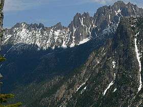
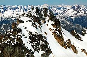
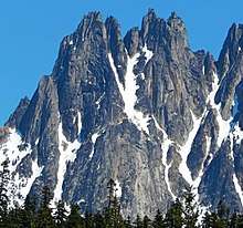
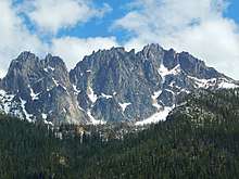
The summit ridge of Silver Star consists of a long ridge of spires (the Wine Spires) leading to the main summit. Vasiliki Ridge radiates north from the Wine Spires, and Snagtooth Ridge extends south from Silver Star. The mountain is a steep ragged wall as seen from the west on Highway 20. The north side glacier reaches to just below the ridge line. The easiest route is up the moderate glacier from the north via Silver Star Creek.
Silver Star Mountain stands within the watershed of the Methow River, which drains into the Columbia River's Lake Pateros reservoir, impounded by Wells Dam. The west and north sides of Silver Star drain into Early Winters Creek, thence into the Methow River. The southeast side of Silver Star drains into Cedar Creek, thence into Early Winters Creek.
Routes
East summit
West summit
- Southwest Buttress class 4
- West Buttress class 5.8 A1 Grade III
- Northeast Ridge class 5.9 Grade III
- Gato Negro class 5.10d
- Silver Star Glacier class 4
Geology
The North Cascades features some of the most rugged topography in the Cascade Range with craggy peaks, ridges, and deep glacial valleys.
Geological events occurring many years ago created the diverse topography and drastic elevation changes over the Cascade Range leading to the various climate differences.
The history of the formation of the Cascade Mountains dates back millions of years ago to the late Eocene Epoch.[2] With the North American Plate overriding the Pacific Plate, episodes of volcanic igneous activity persisted.[2] In addition, small fragments of the oceanic and continental lithosphere called terranes created the North Cascades about 50 million years ago.[2] Silver Star Mountain is located in the Golden Horn batholith and composed of granite like many of the peaks in the Washington Pass area.
During the Pleistocene period dating back over two million years ago, glaciation advancing and retreating repeatedly scoured the landscape leaving deposits of rock debris.[2] The “U”-shaped cross section of the river valleys are a result of recent glaciation. Uplift and faulting in combination with glaciation have been the dominant processes which have created the tall peaks and deep valleys of the North Cascades area.
References
External links
- "Silver Star Mountain". Geographic Names Information System. United States Geological Survey.
- "Silver Star Mountain, Washington". Peakbagger.com. Retrieved 2011-05-07.
- "Silver Star Mountain". SummitPost.org. Retrieved 2011-05-07.