Sillane
| Sillane | |
|---|---|
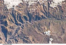 The Colca River and Sillane north of it (center) as seen from the ISS | |
| Highest point | |
| Elevation | 5,200 m (17,100 ft) [1] |
| Coordinates | 15°31′59″S 71°54′02″W / 15.53306°S 71.90056°WCoordinates: 15°31′59″S 71°54′02″W / 15.53306°S 71.90056°W |
| Geography | |
 Sillane Peru | |
| Location | Peru, Arequipa Region, Caylloma Province, Tapay District |
| Parent range | Andes, Chila |
Sillane (possibly from Aymara silla cane of maize,[2] -ni a suffix, "the one with canes of maize") is a mountain in the Chila mountain range in the Andes of Peru which reaches a height of approximately 5,200 m (17,100 ft). It is located in the Arequipa Region, Caylloma Province, on the border of the districts of Madrigal and Tapay. Sillane lies north of the Colca River, northeast of the village of Tapay.[1]
References
- 1 2 escale.minedu.gob.pe - UGEL map of the Caylloma Province 1 (Arequipa Region)
- ↑ Radio San Gabriel, "Instituto Radiofonico de Promoción Aymara" (IRPA) 1993, Republicado por Instituto de las Lenguas y Literaturas Andinas-Amazónicas (ILLLA-A) 2011, Transcripción del Vocabulario de la Lengua Aymara, P. Ludovico Bertonio 1612 (Spanish-Aymara-Aymara-Spanish dictionary)
This article is issued from
Wikipedia.
The text is licensed under Creative Commons - Attribution - Sharealike.
Additional terms may apply for the media files.