Sill (river)
| Sill | |
|---|---|
 Sill Fall | |
| Country | Austria, Tyrol |
| Physical characteristics | |
| Main source | east of Brenner pass |
| River mouth |
Inn 47°16′39″N 11°25′08″E / 47.27750°N 11.41889°ECoordinates: 47°16′39″N 11°25′08″E / 47.27750°N 11.41889°E |
| Length | 43.5 km (27.0 mi) [1] |
| Basin features | |
| Progression | Inn→ Danube→ Black Sea |
| Basin size | 853 km2 (329 sq mi) [1] |
| Tributaries |
|
The Sill is a 43-kilometer river in Tyrol, Austria.[1] It is one of the larger tributaries of the Inn in the Austrian Tyrol. It flows north through the Wipptal (Wipp Valley) to Innsbruck. Its source lies east of the Brenner Pass. At the "Sillzwickel" - the name of the point where it meets the Inn at Innsbruck - there is a recreation area with cycling trails.
The Viggarbach merges with it in Schönberg.
The natural river basin is 853 km²;[1] 31.6 km² are covered in glacier ice.
The water power generated by the river flow is used for three power plants providing the city and environs with electricity.
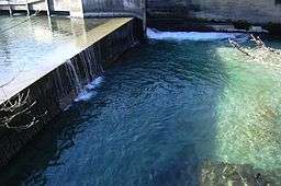
Waterfalls on the river include Sill Fall, which has a height of 4 metres, and from where water is taken out for urban use. In the fall basin, fish such as trout can be found. The Bretterkeller waterfall is located at the bottom of the Paschberg in the city area of Innsbruck.
The Sill features prominently in the stories Amras and Der Wetterfleck by the Austrian writer Thomas Bernhard.
References