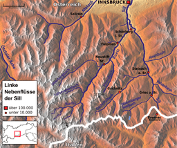
Ruetz
| Ruetz | |
|---|---|
 Course of the Ruetz river | |
| Other name(s) | Ruetzbach |
| Country | Austria, Tyrol |
| Physical characteristics | |
| Main source | Stubai Alps |
| River mouth |
Sill 47°12′49″N 11°23′24″E / 47.2137°N 11.3900°ECoordinates: 47°12′49″N 11°23′24″E / 47.2137°N 11.3900°E |
| Length | 36.8 km (22.9 mi) [1] |
| Basin features | |
| Progression | Sill→ Inn→ Danube→ Black Sea |
| Basin size | 320 km2 (120 sq mi) [1] |
The Ruetz flows from the glacier area of the Stubaital to the Wipptal in north-east direction. Near the famous "Europe bridge", it merges with the Sill River after a route length of appr. 37 km. The river crosses straight the village of Fulpmes providing a nearby power station of the Austrian Railway Services with electricity.
As a typical rapid-river the Ruetz is pretty dangerous and full of rapids. Before several defence structures had been constructed, it was quite feared due to floods. However, the water quality is very good and several communities in the Stubai Valley use the river as drinking water resource.
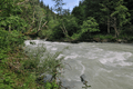 The Ruetz at Schönberg
References
This article is issued from
Wikipedia.
The text is licensed under Creative Commons - Attribution - Sharealike.
Additional terms may apply for the media files.