Silda, Finnmark
| Native name: Sildi | |
|---|---|
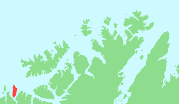 | |
 Silda Location of the island  Silda Silda (Norway) | |
| Geography | |
| Location | Finnmark, Norway |
| Coordinates | 70°19′18″N 21°44′23″E / 70.3216°N 21.7398°ECoordinates: 70°19′18″N 21°44′23″E / 70.3216°N 21.7398°E |
| Area | 48 km2 (19 sq mi) |
| Length | 15 km (9.3 mi) |
| Width | 4 km (2.5 mi) |
| Highest elevation | 628 m (2,060 ft) |
| Highest point | Sunnáčohkka |
| Administration | |
|
Norway | |
| County | Finnmark |
| Municipality | Loppa Municipality |
| Demographics | |
| Population | 0 |
Silda (Northern Sami: Sildi) is an uninhabited island in Loppa Municipality in Finnmark county, Norway. The 48-square-kilometre (19 sq mi) island lies in the Lopphavet Sea, north of the villages of Bergsfjord and Sør-Tverrfjord on the mainland. The island is very mountainous, the tallest being the 628-metre (2,060 ft) tall mountain Sunnáčohkka. The name of the island may be derived from the Norwegian words for "seal" or "herring".[1]
See also
References
- ↑ Askheim, Svein, ed. (2018-02-20). "Silda i Loppa". Store norske leksikon (in Norwegian). Kunnskapsforlaget. Retrieved 2018-06-23.
This article is issued from
Wikipedia.
The text is licensed under Creative Commons - Attribution - Sharealike.
Additional terms may apply for the media files.